NASA imagery reveals strength in Tropical Storm Michael's 'arm'
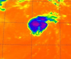
This is Tropical Storm Michael on Sept. 5 at 0611 UTC (2:11 a.m. EDT). Noticed the strongest thunderstorms and coldest cloud top temperatures (purple) around the center of circulation and in a band of thunderstorms to the northeast of the center.<br><br>Credit: NASA JPL, Ed Olsen<br>
The Atmospheric Infrared Sounder (AIRS) instrument that flies aboard NASA's Aqua satellite captured in infrared image of Tropical Storm Michael on Sept. 5 at 0611 UTC (2:11 a.m. EDT) and noticed the strongest thunderstorms and coldest cloud top temperatures around the center of circulation and in a band of thunderstorms to the northeast of Michael's center.
Those cloud top temperatures were as cold as -63 Fahrenheit (-52 Celsius) and indicated strong thunderstorms with heavy rainfall.
On Sept. 5 at 11 a.m. EDT, Michael had maximum sustained winds near 50 mph (85 kmh). The area of tropical storm force winds have expanded over the last two days and now extend outward up to 60 miles (95 km).
Michael's center was about 1155 miles (1,855 km) west-southwest of the Azores islands, near latitude 28.3 north and longitude 43.3 west. Michael is moving toward the northeast near 6 mph (9 kmh) and is expected to continue in that direction for the next couple of days.
The National Hurricane Center expects the wind shear that has been battering Michael over the last couple of days to relax, which may allow Michael to become a hurricane by Friday, Sept. 7.
Media Contact
More Information:
http://www.nasa.govAll latest news from the category: Earth Sciences
Earth Sciences (also referred to as Geosciences), which deals with basic issues surrounding our planet, plays a vital role in the area of energy and raw materials supply.
Earth Sciences comprises subjects such as geology, geography, geological informatics, paleontology, mineralogy, petrography, crystallography, geophysics, geodesy, glaciology, cartography, photogrammetry, meteorology and seismology, early-warning systems, earthquake research and polar research.


Newest articles

A universal framework for spatial biology
SpatialData is a freely accessible tool to unify and integrate data from different omics technologies accounting for spatial information, which can provide holistic insights into health and disease. Biological processes…

How complex biological processes arise
A $20 million grant from the U.S. National Science Foundation (NSF) will support the establishment and operation of the National Synthesis Center for Emergence in the Molecular and Cellular Sciences (NCEMS) at…

Airborne single-photon lidar system achieves high-resolution 3D imaging
Compact, low-power system opens doors for photon-efficient drone and satellite-based environmental monitoring and mapping. Researchers have developed a compact and lightweight single-photon airborne lidar system that can acquire high-resolution 3D…

