NASA identifies where Tropical Storm Gaemi's power lies
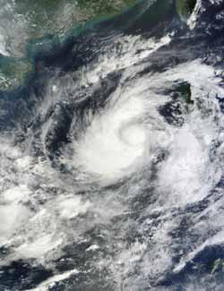
NASA's Terra satellite passed over Tropical Storm Gaemi on Oct. 3 at 0300 UTC (11:00 p.m. EDT, Oct. 2) and the MODIS instrument captured this true-color image. Strong thunderstorms surrounded the center, as is apparent in the circle in the middle of the storm, as well as in a wide band that stretches from north to west, and southwest of the center.<br><br>Credit: NASA Goddard/MODIS Rapid Response Team<br>
NASA's Terra satellite passed over Tropical Storm Gaemi on Oct. 3 at 0300 UTC (11:00 p.m. EDT, Oct. 2) and the Moderate Resolution Imaging Spectroradiometer (MODIS) instrument captured a true-color image of the storm.
The image showed a bright white, rounded area around the center that indicated higher, stronger thunderstorms. Higher, stronger thunderstorms also wrapped around the center in a wide band that stretches from north to west, and southwest of the center.
On Oct. 3, 2012 at 1500 UTC (11 a.m. EDT) Tropical Storm Gaemi had maximum sustained winds near 55 knots (63.2 mph/102 kph). Gaemi's center was located about 575 nautical miles (661.7 miles/1,065 km) east of Hue, Vietnam, near 15.3 North latitude and 117.5 East longitude. Gaemi is moving to the west-southwest at 4knots (4.6 mph/7.4 kph).
Gaemi is now turning west and is forecast to head for a landfall on Oct. 6 on the Vietnamese coastline, south of Hue.
Media Contact
More Information:
http://www.nasa.govAll latest news from the category: Earth Sciences
Earth Sciences (also referred to as Geosciences), which deals with basic issues surrounding our planet, plays a vital role in the area of energy and raw materials supply.
Earth Sciences comprises subjects such as geology, geography, geological informatics, paleontology, mineralogy, petrography, crystallography, geophysics, geodesy, glaciology, cartography, photogrammetry, meteorology and seismology, early-warning systems, earthquake research and polar research.


Newest articles

A universal framework for spatial biology
SpatialData is a freely accessible tool to unify and integrate data from different omics technologies accounting for spatial information, which can provide holistic insights into health and disease. Biological processes…

How complex biological processes arise
A $20 million grant from the U.S. National Science Foundation (NSF) will support the establishment and operation of the National Synthesis Center for Emergence in the Molecular and Cellular Sciences (NCEMS) at…

Airborne single-photon lidar system achieves high-resolution 3D imaging
Compact, low-power system opens doors for photon-efficient drone and satellite-based environmental monitoring and mapping. Researchers have developed a compact and lightweight single-photon airborne lidar system that can acquire high-resolution 3D…

