NASA Catches Two Tropical Troublemakers in Northwestern Pacific: Halong and 96W
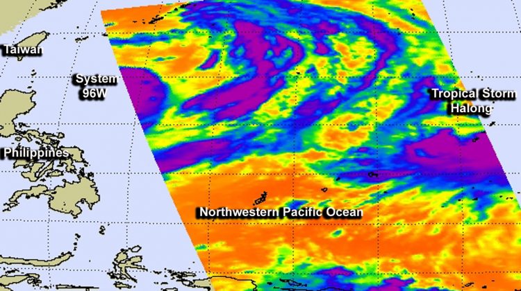
NASA's Aqua satellite flew over both developing System 96W (left) and Tropical Storm Halong (right) on July 30 and had powerful thunderstorms with cloud top temperatures as cold as -63F/-52C. Image Credit: NASA JPL, Ed Olsen
NASA's Aqua satellite flew over both Tropical Storm Halong and developing System 96W early on July 30 and the Atmospheric Infrared Sounder (AIRS) instrument captured infrared data on them in one image.
Both systems show powerful thunderstorms stretching high into the troposphere with cloud top temperatures as cold as -63F/-52C. Those thunderstorms have the potential for heavy rainfall.
The latest update from the Joint Typhoon Warning Center (JTWC) places the center of the storm about 75 nautical miles (86.3 miles/138.9 km) northwest of Navsta, Guam, near 14.4 north latitude and 143.4 east longitude. Halong's maximum sustained winds were near 50 knots (57.4 mph/92.6 kph).
The JTWC expects Halong to strengthen to typhoon status by August 1. Halong was moving to the west at 8 knots (9.2 mph/14.8 kph).
Halong is moving through the Marianas Islands and has generated a Tropical Storm Warning for Guam and a Typhoon Warning for Rota.
To the west of Tropical Storm Halong lies the developing tropical low known as System 96W. Enhanced infrared satellite imagery on July 30 showed that System 96W appeared to be more organized.
System 96W is now located near 19.9 north latitude and 130.5 east longitude, about 416 nautical miles south-southeast of Kadena Air Base, Okinawa, Japan.
The Joint Typhoon Warning Center (JTWC) described System 96W as a monsoon depression with improved deep convection begins to consolidate as a typical tropical cyclone. Maximum sustained surface winds are estimated between 20 to 25 knots (23.0 to 28.7 mph / 37.0 to 46.3 kph. Minimum sea level pressure is estimated to be near 996 millibars.
The JTWC gives System 96W a high chance of becoming the Northwestern Pacific's next tropical depression in the next 24 hours.
Text credit: Rob Gutro
NASA's Goddard Space Flight Center
Media Contact
More Information:
http://www.nasa.gov/content/goddard/11w-northwestern-pacific-ocean/All latest news from the category: Earth Sciences
Earth Sciences (also referred to as Geosciences), which deals with basic issues surrounding our planet, plays a vital role in the area of energy and raw materials supply.
Earth Sciences comprises subjects such as geology, geography, geological informatics, paleontology, mineralogy, petrography, crystallography, geophysics, geodesy, glaciology, cartography, photogrammetry, meteorology and seismology, early-warning systems, earthquake research and polar research.


Newest articles

A universal framework for spatial biology
SpatialData is a freely accessible tool to unify and integrate data from different omics technologies accounting for spatial information, which can provide holistic insights into health and disease. Biological processes…

How complex biological processes arise
A $20 million grant from the U.S. National Science Foundation (NSF) will support the establishment and operation of the National Synthesis Center for Emergence in the Molecular and Cellular Sciences (NCEMS) at…

Airborne single-photon lidar system achieves high-resolution 3D imaging
Compact, low-power system opens doors for photon-efficient drone and satellite-based environmental monitoring and mapping. Researchers have developed a compact and lightweight single-photon airborne lidar system that can acquire high-resolution 3D…

