NASA catches Melissa's fickle life as a tropical storm
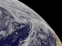
NOAA's GOES-East satellite captured this visible image of Tropical Storm Melissa in the Central Atlantic on Nov. 21 at 1445 UTC/9:45 a.m. EST.<br><br>Credit: NASA GOES Project<br>
NOAA's GOES-East satellite captured images that were made into an animation showing Melissa's conversion from a subtropical to tropical storm and now making another change.
NOAA's GOES-East satellite sits in a fixed position over the Atlantic Ocean and captures visible and infrared imagery continually. At the NASA GOES Project at NASA's Goddard Space Flight Center in Greenbelt, Md. many images were combined into an animation to make a video that shows Melissa's transformations over Nov. 18 and Nov. 19.
On Nov 19 at 10 a.m. EST, Melissa's maximum sustained winds were near 50 mph/85 kph and it was bringing gale-force winds over parts of the western and central Azores Islands .
Melissa was centered near 40.0 north latitude and 34.8 west longitude, about 440 miles/710 kilometers west-northwest of the Azores. Melissa was moving to the east-northeast at a speedy 32 mph/52 kph and had a minimum central pressure near 984 millibars. The center of Melissa will pass north of the western Azores today, Nov. 21.
The National Hurricane Center expects Melissa to become post-tropical later today. Gradual weakening is forecast during the next two days.
Media Contact
More Information:
http://www.nasa.govAll latest news from the category: Earth Sciences
Earth Sciences (also referred to as Geosciences), which deals with basic issues surrounding our planet, plays a vital role in the area of energy and raw materials supply.
Earth Sciences comprises subjects such as geology, geography, geological informatics, paleontology, mineralogy, petrography, crystallography, geophysics, geodesy, glaciology, cartography, photogrammetry, meteorology and seismology, early-warning systems, earthquake research and polar research.


Newest articles

A universal framework for spatial biology
SpatialData is a freely accessible tool to unify and integrate data from different omics technologies accounting for spatial information, which can provide holistic insights into health and disease. Biological processes…

How complex biological processes arise
A $20 million grant from the U.S. National Science Foundation (NSF) will support the establishment and operation of the National Synthesis Center for Emergence in the Molecular and Cellular Sciences (NCEMS) at…

Airborne single-photon lidar system achieves high-resolution 3D imaging
Compact, low-power system opens doors for photon-efficient drone and satellite-based environmental monitoring and mapping. Researchers have developed a compact and lightweight single-photon airborne lidar system that can acquire high-resolution 3D…

