NASA'S TRMM Satellite provides rainfall estimate for Cyclone Phet
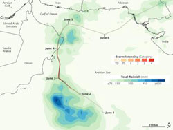
This TRMM satellite rainfall estimate map showed Cyclone Phet\'s heaviest rainfall (600 or more millimeters/23.6 or more inches) occurred over open waters of the Arabian Sea (blue) Northeast Oman received as much as 450 millimeters (17.7 inches), while Pakistan received between 150-300 millimeters/ 5.9-11.8 inches. The colored line indicates storm track and intensity. Credit: NASA /Jesse Allen<br>
TRMM satellite rainfall data estimated Cyclone Phet's heaviest rainfall (600 or more millimeters/23.6 or more inches) occurred over open waters of the Arabian Sea. One area of northeast Oman received as much as 450 millimeters (17.7 inches), while Pakistan received between 150-300 millimeters/ 5.9-11.8 inches as Phet made landfall there this past weekend.
NASA's Jesse Allen created a rainfall image is based on data from the Multi-satellite Precipitation Analysis (MPA) produced at NASA's Goddard Space Flight Center in Greenbelt, Md. The image showed both rainfall amounts and the storm track for Phet from May 31 to June 6, 2010. The MPS analysis estimates rainfall by combining measurements from many satellites and calibrating them using rainfall measurements from the Tropical Rainfall Measuring Mission (TRMM) satellite.
Tropical Cyclone Phet brought not just strong winds but also heavy rains to the Arabian Sea, the Arabian Peninsula, and the coast of Pakistan in late May and early June. Phet reached its greatest intensity off the coast of Oman on June 3. After making landfall in Oman, Phet dissipated somewhat, but remained organized enough to move back over the Arabian Sea toward Pakistan.
Media Contact
More Information:
http://www.nasa.govAll latest news from the category: Earth Sciences
Earth Sciences (also referred to as Geosciences), which deals with basic issues surrounding our planet, plays a vital role in the area of energy and raw materials supply.
Earth Sciences comprises subjects such as geology, geography, geological informatics, paleontology, mineralogy, petrography, crystallography, geophysics, geodesy, glaciology, cartography, photogrammetry, meteorology and seismology, early-warning systems, earthquake research and polar research.


Newest articles

A universal framework for spatial biology
SpatialData is a freely accessible tool to unify and integrate data from different omics technologies accounting for spatial information, which can provide holistic insights into health and disease. Biological processes…

How complex biological processes arise
A $20 million grant from the U.S. National Science Foundation (NSF) will support the establishment and operation of the National Synthesis Center for Emergence in the Molecular and Cellular Sciences (NCEMS) at…

Airborne single-photon lidar system achieves high-resolution 3D imaging
Compact, low-power system opens doors for photon-efficient drone and satellite-based environmental monitoring and mapping. Researchers have developed a compact and lightweight single-photon airborne lidar system that can acquire high-resolution 3D…

