NASA's Global Hawk Investigating Atlantic Tropical Depression 14
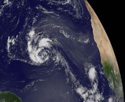
This visible image of System 91L was captured by NOAA's GOES-13 satellite at 1145 UTC (7:45 a.m. EDT). Credit: NASA's GOES Project <br>
NASA's latest hurricane science field campaign began on Sept. 7 when the Global Hawk flew over Hurricane Leslie in the Atlantic Ocean. HS3 marks the first time NASA is flying Global Hawks from the U.S. East Coast.
According to Chris Naftel, project manager of NASA's Global Hawk program at NASA's Dryden Flight Research Center, Edwards Air Base, Calif., the Global Hawk aircraft took off at 7:06 a.m. EDT and headed for Tropical Depression 14, which at the time of take-off, was still a developing low pressure area called System 91L.
At 1500 UTC (11 a.m. EDT), Tropical Depression 14 was located near 16.3 North latitude and 43.1 West longitude, about 1,210 miles (1,950 km) east of the Lesser Antilles. The depression had maximum sustained winds near 35 mph. It was moving to the west near 10 mph (17 kmh) and had a minimum central pressure of 1006 millibars.
The National Hurricane Center expects Tropical Depression 14 to strengthen into a tropical storm over the next 48 hours, and turn to the northwest.
On Sept. 10, the Tropical Rainfall Measuring Mission (TRMM) satellite passed over Tropical Depression 14, when it was known as low pressure System 91L and data from TRMM's Microwave Imager (TMI) and Precipitation Radar (PR) were used to create a rainfall analysis. The data was overlaid on a combination infrared and visible image from TRMM's Visible and InfraRed Scanner (VIRS) and showed that System 91L was getting organized and that convective storms reaching heights of about 13km (~8.1 miles) were dropping heavy rain to the northwest and northeast of the center of the circulation.
The HS3 mission targets the processes that underlie hurricane formation and intensity change. The data collected will help scientists decipher the relative roles of the large-scale environment and internal storm processes that shape these systems.
HS3 is supported by several NASA centers including Wallops; Goddard; Dryden; Ames Research Center, Moffett Field, Calif.; Marshall Space Flight Center, Huntsville, Ala.; and the Jet Propulsion Laboratory, Pasadena, Calif. HS3 also has collaborations with partners from government agencies and academia.
HS3 is an Earth Venture mission funded by NASA's Science Mission Directorate in Washington. Earth Venture missions are managed by NASA's Earth System Science Pathfinder Program at the agency's Langley Research Center in Hampton, Va. The HS3 mission is managed by the Earth Science Project Office at NASA's Ames Research Center.
Rob Gutro
NASA's Goddard Space Flight Center, Greenbelt, Md.
Media Contact
All latest news from the category: Earth Sciences
Earth Sciences (also referred to as Geosciences), which deals with basic issues surrounding our planet, plays a vital role in the area of energy and raw materials supply.
Earth Sciences comprises subjects such as geology, geography, geological informatics, paleontology, mineralogy, petrography, crystallography, geophysics, geodesy, glaciology, cartography, photogrammetry, meteorology and seismology, early-warning systems, earthquake research and polar research.


Newest articles

A universal framework for spatial biology
SpatialData is a freely accessible tool to unify and integrate data from different omics technologies accounting for spatial information, which can provide holistic insights into health and disease. Biological processes…

How complex biological processes arise
A $20 million grant from the U.S. National Science Foundation (NSF) will support the establishment and operation of the National Synthesis Center for Emergence in the Molecular and Cellular Sciences (NCEMS) at…

Airborne single-photon lidar system achieves high-resolution 3D imaging
Compact, low-power system opens doors for photon-efficient drone and satellite-based environmental monitoring and mapping. Researchers have developed a compact and lightweight single-photon airborne lidar system that can acquire high-resolution 3D…

