NASA's Aqua Satellite Sees Tropical Storm Kristy Weaken, Other System Developing
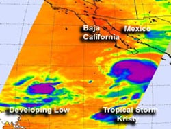
This infrared image of shows a developing area of low pressure southwest of Tropical Storm Kristy in the eastern Pacific Ocean. The image was taken on Sept. 14 at 5:23 a.m. EDT. Purple areas indicate the strongest thunderstorms and heaviest rainfall. Credit: NASA JPL, Ed Olsen<br>
NASA's Aqua satellite passed over the eastern Pacific Ocean on Sept. 14 at 5:23 a.m. ED, and the Atmospheric Infrared Sounder (AIRS) instrument captured an infrared image of Kristy and a new developing low pressure area.
The infrared data indicated the strongest thunderstorms and heaviest rainfall were to the southeast of the center of circulation. Wind shear from the northwest has pushed the bulk of clouds and showers to the southeast, while the low-level center is on the northwestern edge of a comma-shaped band of thunderstorms.
Kristy is close enough to shore to create rough seas. Ocean swells will affect the coasts of southwestern Mexico and southern Baja California and may cause life-threatening surf and rip-tide conditions.
On Friday, Sept. 14 at 11 a.m. EDT, Tropical Storm Kristy's maximum sustained winds are near 50 mph (85 kmh). Kristy is located about 260 miles (415 km) southwest of the southern tip of Baja California, near latitude 20.4 north and longitude 112.9 west. Kristy is moving west-northwest near 10 mph (17 kmh) and a gradual turn to the northwest is expected later on Sept. 14.
Kristy is expected to weaken to a remnant low pressure area on Sunday, Sept. 16 because of adverse atmospheric conditions and its movement over cooler waters.
Watching Two Other Developing Systems
It seems like the eastern Pacific Ocean is now suddenly trying to play catch up with the Atlantic. The eastern Pacific has had 11 tropical depressions, while the Atlantic has had 14 so far.
Satellites are helping forecasters keep an eye on two other developing low pressure areas to the west of Tropical Storm Kristy. The first area is about 900 miles southwest of the southernmost tip of Baja California. Environmental conditions are expected to improve over the weekend of Sept. 15 as the low moves slowly westward. The low has a 50 percent chance of development over the weekend.
The second area is located much further west and is about 1,700 miles west-southwest of the southern tip of Baja California. Environmental conditions are expected to become less conducive for development during the weekend of Sept. 15, and on Sept. 14, satellite data showed that the showers and thunderstorms associated with the low had become more disorganized. The National Hurricane Center gives that low pressure area a 20 percent chance of development.
Text Credit: Rob Gutro
NASA's Goddard Space Flight Center, Greenbelt, Md.
Media Contact
More Information:
http://www.nasa.govAll latest news from the category: Earth Sciences
Earth Sciences (also referred to as Geosciences), which deals with basic issues surrounding our planet, plays a vital role in the area of energy and raw materials supply.
Earth Sciences comprises subjects such as geology, geography, geological informatics, paleontology, mineralogy, petrography, crystallography, geophysics, geodesy, glaciology, cartography, photogrammetry, meteorology and seismology, early-warning systems, earthquake research and polar research.


Newest articles

A universal framework for spatial biology
SpatialData is a freely accessible tool to unify and integrate data from different omics technologies accounting for spatial information, which can provide holistic insights into health and disease. Biological processes…

How complex biological processes arise
A $20 million grant from the U.S. National Science Foundation (NSF) will support the establishment and operation of the National Synthesis Center for Emergence in the Molecular and Cellular Sciences (NCEMS) at…

Airborne single-photon lidar system achieves high-resolution 3D imaging
Compact, low-power system opens doors for photon-efficient drone and satellite-based environmental monitoring and mapping. Researchers have developed a compact and lightweight single-photon airborne lidar system that can acquire high-resolution 3D…

