NASA's Aqua Satellite sees Tropical Depression Anthony heading toward Australia
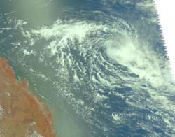
NASA\'s Aqua Satellite captured this visible image on Jan. 26 at 03:23 UTC of a now weakened Tropical Depression Anthony as it continues to weaken in the South Pacific Ocean. Eastern Australia can be seen on the left side of this image. Credit: NASA JPL, Ed Olsen<br>
The Atmospheric Infrared Sounder (AIRS) instrument that flies aboard NASA's Aqua satellite captured a visible image on Jan. 26 at 03:23 UTC of Tropical Depression Anthony in the South Pacific Ocean. The image revealed a cloud-filled center of the storm.
At 0600 UTC (1 a.m. EST) on January 26, Anthony had progressed west and was now about 455 nautical miles west-northwest of Nomeau, New Caledonia. That places Anthony's center near 19.2 South and 159.1 East. Maximum sustained surface winds are estimated at 25 to 30 knots (28 mph/46 km/hr to 34 mph/55 km/hr) meaning that Anthony is still at tropical depression status.
The infrared imagery from the AIRS instrument showed a well-defined low level circulation center, although dry air is now wrapping into Anthony's northern quadrant. Dry air saps the moisture that creates the thunderstorms that power a tropical cyclone. Generally, the storm's convection (rapidly rising air that creates those thunderstorms) is weak throughout the storm, and only isolated strong areas of convection appear in the southeastern quadrant. That may change in the next day or two, however, as Anthony moves into an area more conducive to maintaining a tropical cyclone.
Vertical wind shear (winds that can weaken a tropical cyclone) has lessened and sea surface temperatures are warm enough to sustain and strengthen a tropical cyclone (between 28 and 30 Celsius/82 and 86 Fahrenheit). Computer forecast models have shown forecasters at the Joint Typhoon Warning Center that as the system tracks westward toward Australia, there is a fair chance that Anthony will regenerate or re-strengthen in the next 24-36 hours. Forecasters in Queensland, Australia will be watching Anthony very closely.
NASA's Hurricane page: www.nasa.gov/hurricane
Media Contact
All latest news from the category: Earth Sciences
Earth Sciences (also referred to as Geosciences), which deals with basic issues surrounding our planet, plays a vital role in the area of energy and raw materials supply.
Earth Sciences comprises subjects such as geology, geography, geological informatics, paleontology, mineralogy, petrography, crystallography, geophysics, geodesy, glaciology, cartography, photogrammetry, meteorology and seismology, early-warning systems, earthquake research and polar research.


Newest articles

A universal framework for spatial biology
SpatialData is a freely accessible tool to unify and integrate data from different omics technologies accounting for spatial information, which can provide holistic insights into health and disease. Biological processes…

How complex biological processes arise
A $20 million grant from the U.S. National Science Foundation (NSF) will support the establishment and operation of the National Synthesis Center for Emergence in the Molecular and Cellular Sciences (NCEMS) at…

Airborne single-photon lidar system achieves high-resolution 3D imaging
Compact, low-power system opens doors for photon-efficient drone and satellite-based environmental monitoring and mapping. Researchers have developed a compact and lightweight single-photon airborne lidar system that can acquire high-resolution 3D…

