Measuring river surface flow with image analysis
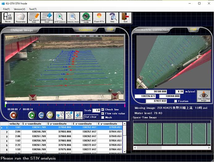
A screenshot of the English-language version of the KU-STIV system, used to measure river flow rate. Credit: Kobe University
Japan is hit by flood-related disasters almost every year – one of the most recent examples occurred in September 2015 when the Kinugawa River collapsed its banks, sending a wall of water into the nearby town of Joso. Accurate data for rainfall and river flow rate are vital elements in creating flood risk management strategies.
Thanks to developments in radar technology, rainfall measurements have become highly precise. However, measuring the flow rate of rivers is still carried out using the old-fashioned method of dropping a stick-shaped float in the river and estimating the flow rate from the float's speed through a section of the river.
When extreme flooding occurs this method becomes difficult to conduct due to the dangers involved, and there are a growing number of cases in which flow rates cannot be measured at the peak of a flood.
The KU-STIV system developed by Professor Fujita uses video footage taken from cameras and drones to measure the river flow rate. The system superimposes “searching lines” (each between 10 and 20 meters long) on footage of the river as measurement standards.
It calculates the flow speed from the time it takes water surface features and floating matter on the surface of the river to cross these lines, then analyses distribution to indirectly calculate the river flow rate.
Surface flow measurements taken using this system were very similar to those taken using acoustic current meters (ADCPs) and it can be used to measure river flow rates faster and more safely than the established method.
KU-STIV has already been adopted by many river consultants and River Offices in Japan's Ministry of Land, Infrastructure, Transport and Tourism, and organizations in Hyogo Prefecture have begun adapting the system for river observation cameras.
An English-language version of the system is also available, and recently Ghana researchers invited by the Japan International Cooperation Agency (JICA) are being trained to use the technology.
“We are aiming to adapt this system for real-time calculations, and at the same time we want to establish this as the standard method for measuring river flow rate both within Japan and overseas” commented Professor Fujita.
Media Contact
All latest news from the category: Earth Sciences
Earth Sciences (also referred to as Geosciences), which deals with basic issues surrounding our planet, plays a vital role in the area of energy and raw materials supply.
Earth Sciences comprises subjects such as geology, geography, geological informatics, paleontology, mineralogy, petrography, crystallography, geophysics, geodesy, glaciology, cartography, photogrammetry, meteorology and seismology, early-warning systems, earthquake research and polar research.


Newest articles

A universal framework for spatial biology
SpatialData is a freely accessible tool to unify and integrate data from different omics technologies accounting for spatial information, which can provide holistic insights into health and disease. Biological processes…

How complex biological processes arise
A $20 million grant from the U.S. National Science Foundation (NSF) will support the establishment and operation of the National Synthesis Center for Emergence in the Molecular and Cellular Sciences (NCEMS) at…

Airborne single-photon lidar system achieves high-resolution 3D imaging
Compact, low-power system opens doors for photon-efficient drone and satellite-based environmental monitoring and mapping. Researchers have developed a compact and lightweight single-photon airborne lidar system that can acquire high-resolution 3D…

