Fires in Papua, Indonesia and New Guinea
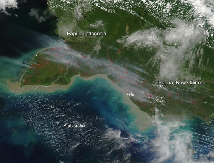
This natural-color satellite image was collected by the Moderate Resolution Imaging Spectroradiometer (MODIS) aboard the Aqua satellite on Sept. 28, 2014. Actively burning areas, detected by MODIS's thermal bands, are outlined in red and there is smoke significant rising from these areas. Credit: NASA image courtesy Jeff Schmaltz, MODIS Rapid Response Team. Caption: NASA/Goddard, Lynn Jenner with information from NASA Study Says Climate Adds Fuel to Asian Wildfire Emissions
Palm oil is increasingly grown for use as a cooking oil and biofuel, while also replacing trans fats in processed foods.
It has become the most widely produced edible oil in the world, and production has swelled in recent years to surpass that of soybean oil.
The environmental effects of such growth have been significant. Land has to be cleared to grow the crop, and the preferred method is fire.
The clearing often occurs in drained peatlands that are otherwise swampy forests where the remains of past plant life have been submerged for centuries in as much as 60 feet of water.
Indonesia has become the third largest greenhouse gas emitter after the United States and China, due primarily to these fire emissions.
With an extended dry season, the peat surface dries out, catches fire, and the lack of rainfall can keep the fires going for months.”
This natural-color satellite image was collected by the Moderate Resolution Imaging Spectroradiometer (MODIS) aboard the Aqua satellite on September 28, 2014.
Actively burning areas, detected by MODIS's thermal bands, are outlined in red and there is smoke significant rising from these areas.
Media Contact
All latest news from the category: Earth Sciences
Earth Sciences (also referred to as Geosciences), which deals with basic issues surrounding our planet, plays a vital role in the area of energy and raw materials supply.
Earth Sciences comprises subjects such as geology, geography, geological informatics, paleontology, mineralogy, petrography, crystallography, geophysics, geodesy, glaciology, cartography, photogrammetry, meteorology and seismology, early-warning systems, earthquake research and polar research.


Newest articles

A universal framework for spatial biology
SpatialData is a freely accessible tool to unify and integrate data from different omics technologies accounting for spatial information, which can provide holistic insights into health and disease. Biological processes…

How complex biological processes arise
A $20 million grant from the U.S. National Science Foundation (NSF) will support the establishment and operation of the National Synthesis Center for Emergence in the Molecular and Cellular Sciences (NCEMS) at…

Airborne single-photon lidar system achieves high-resolution 3D imaging
Compact, low-power system opens doors for photon-efficient drone and satellite-based environmental monitoring and mapping. Researchers have developed a compact and lightweight single-photon airborne lidar system that can acquire high-resolution 3D…

