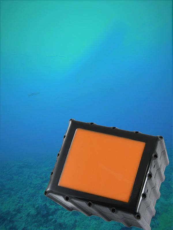
3D Sonar Technology Made in Germany – High-resolution 3D imaging on short distances

Real-time 3D sonar camera Fraunhofer IBMT
The technology of sonar – the measurement of structures under water with sound signals – is used for many years in the field of seafloor mapping, in the fishery industry or for the search for sunken objects. The sonar systems used for these tasks are usually designed for long measurement distances and therefore provide a rather low spatial resolution.
Many applications under water demand a high-resolution visualization of the surrounding environment on short distances. Optical video cameras are often used for this purpose. However, these systems are often inapplicable in turbid waters leading to the abort of operations in some cases. By the help of new 3D sonar systems, these tasks can be accomplished more efficiently and precisely.
The Business Unit Sonar of the Main Department of Ultrasound at the Fraunhofer Institute for Biomedical Engineering IBMT in Sulzbach (Germany) concentrates the previous and the future research and development activities in the field of acoustic underwater measurements.
One focus of the recent research and development is on the high-resolution volumetric sonar imaging at distances up to 25 m. High-resolution in this context means the imaging of structures in the range of some centimeters at distances of few meters. At the moment, three different imaging sonar systems are available as demonstrators which are used for labor and field measurements on various objects and structures.
One of these systems, a multibeam echosounder (MBES), generates a sound fan, which is moved along the measurement object. While doing so, the position of the sonar antenna is tracked continuously via GPS so that the single image slices can be subsequently merged correctly to form an accurate representation of the measured structure. The system is suitable for all kinds of measurements on stationary structures from distances up to 15 m.
Real-time 3D imaging
If dynamic processes are supposed to be visualized, a volumetric imaging in real-time is necessary. For this purpose, two additional sonar systems have been developed. Due to their operational mode, these systems provide a three-dimensional visualization of their environment from a fixed position. And this with the same high spatial resolution as the multibeam echosounder.
One of these systems is constructed in a pressure-resistant version, so that even a deep-sea operation up to 600 bar can be performed. Additionally, a miniaturization of the systems is in progress.
Besides the 3D imaging systems, the Fraunhofer IBMT is developing other sonar systems like a sediment penetrating sub-bottom-profiler for the measurement of sedimentary layers in the seafloor with centimeter precision.
The Fraunhofer IBMT presents the whole range of its sonar technologies at this year's OCEANS conference in Aberdeen from 19th to 22nd of June (Booth No. 4). Here, interested industrial companies as well as research groups can inform about the competences and services of the Business Unit Sonar.
Contact:
Dipl.-Ing. Michael Ehrhardt
Business Unit Sonar
Fraunhofer-Institute for Biomedical Engineering IBMT
Joseph-von-Fraunhofer-Weg 1
66280 Sulzbach
Germany
Fon: +49 6897 / 9071 330
Fax: +49 6897 / 9071 302
E-Mail: michael.ehrhardt@ibmt.fraunhofer.de
https://www.ultrasound.fraunhofer.de
https://www.ibmt.fraunhofer.de/en.html
https://www.ibmt.fraunhofer.de/en/ibmt-core-competences/ibmt-ultrasound.html
https://www.ibmt.fraunhofer.de/en/ibmt-core-competences/ibmt-ultrasound/ibmt-son…
Media Contact
All latest news from the category: Earth Sciences
Earth Sciences (also referred to as Geosciences), which deals with basic issues surrounding our planet, plays a vital role in the area of energy and raw materials supply.
Earth Sciences comprises subjects such as geology, geography, geological informatics, paleontology, mineralogy, petrography, crystallography, geophysics, geodesy, glaciology, cartography, photogrammetry, meteorology and seismology, early-warning systems, earthquake research and polar research.
Newest articles

A universal framework for spatial biology
SpatialData is a freely accessible tool to unify and integrate data from different omics technologies accounting for spatial information, which can provide holistic insights into health and disease. Biological processes…

How complex biological processes arise
A $20 million grant from the U.S. National Science Foundation (NSF) will support the establishment and operation of the National Synthesis Center for Emergence in the Molecular and Cellular Sciences (NCEMS) at…

Airborne single-photon lidar system achieves high-resolution 3D imaging
Compact, low-power system opens doors for photon-efficient drone and satellite-based environmental monitoring and mapping. Researchers have developed a compact and lightweight single-photon airborne lidar system that can acquire high-resolution 3D…


