Mauna Loa: innovative research helps predict lava flow
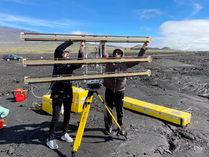
University of South Florida scientists Mahsa Afra (left) and Taha Sadeghi Chorsiset set up an instrument that uses radar to measure the flow of volcanic lava at Mauna Loa in Hawaii.
Credit: University of South Florida
Data collection uses a rare, ground-based instrument to pinpoint where and how quickly the landscape is changing.
A team from the University of South Florida is on the ground in Hawaii studying Mauna Loa, the largest active volcano in the world, to improve efforts that can help protect residents from lava flow. While slow-moving, lava averages 2,200 degrees Fahrenheit and destroys everything in its path.
The team is collecting data that will be used to create models that can help improve lava flow forecasting tools that are useful in determining how hazards impact populations. One such tool, known as MOLASSES, is a simulation engine that forecasts inundation areas of lava flow.
MOLASSES was created by USF geosciences Professor Chuck Connor, who says using the radar to gather data is essential in understanding volcano topography and improving the lava flow models.
“We want to make hazard maps that help people understand where they live and what the risks are,” Connor said. “We can’t stop a volcano from erupting, but we can give people warning about the lava flow.”
Shortly after Mauna Loa’s eruption in late November – the first since 1984 – USF geosciences Professor Tim Dixon sent two graduate students, Taha Chorsi and Mahsa Afra, to Hawaii with a Terrestrial Radar Interferometer, a rare, ground-based instrument that measures where the landscape is changing and how quickly those changes are occurring.
Chorsi and Afra delivered the radar to USF alumna Lis Gallant, a National Science Foundation postdoctoral research fellow at the United States Geological Survey Hawaiian Volcano Observatory.
Using the radar, the USF scientists were able to capture the thickening of Mauna Loa’s lava flows. The novelty of the ground-based instrument is its ability to measure the lava’s surface and create a three-dimensional map within a span of minutes.
“A lot of volcano science happens in hostile terrains,” Gallant said. “This radar is a particularly powerful instrument because it can see through moisture, and now, we can definitely say it would be well-suited in areas where visibility is poor and to immediately help hazard response.”
The team will review this data over the next several months to determine where the Mauna Loa lava flow was moving and the velocities of those movements. The data can be used to better understand how lava flows move and advance, which in turn can be used by scientists to improve tools used to forecast lava flow hazards through models.
Dixon has had great success using the radar to monitor Earth movements in glaciers, landslides, earthquakes and volcanoes. Many of his students, including Chorsi and Afra, have worked alongside him over the years to learn the radar and develop a user manual.
“There’s probably only a hundred people in the world who can successfully use this instrument,” Dixon said.
About the University of South Florida
The University of South Florida, a high-impact global research university dedicated to student success, generates an annual economic impact of more than $6 billion. Over the past 10 years, no other public university in the country has risen faster in U.S. News and World Report’s national university rankings than USF. Serving more than 50,000 students on campuses in Tampa, St. Petersburg and Sarasota-Manatee, USF is designated as a Preeminent State Research University by the Florida Board of Governors, placing it in the most elite category among the state’s 12 public universities. USF has earned widespread national recognition for its success graduating under-represented minority and limited-income students at rates equal to or higher than white and higher income students. USF is a member of the American Athletic Conference. Learn more at www.usf.edu.
Images and video: https://usf.app.box.com/s/9gojapq3j6zrcej1t9rbs2h2z1529rq3
Note: Interviews are available with members of the research team currently on the ground in Hawaii.
Media Contact
John Dudley
University of South Florida
jjdudley@usf.edu
Cell: 8144903290
All latest news from the category: Earth Sciences
Earth Sciences (also referred to as Geosciences), which deals with basic issues surrounding our planet, plays a vital role in the area of energy and raw materials supply.
Earth Sciences comprises subjects such as geology, geography, geological informatics, paleontology, mineralogy, petrography, crystallography, geophysics, geodesy, glaciology, cartography, photogrammetry, meteorology and seismology, early-warning systems, earthquake research and polar research.


Newest articles

A universal framework for spatial biology
SpatialData is a freely accessible tool to unify and integrate data from different omics technologies accounting for spatial information, which can provide holistic insights into health and disease. Biological processes…

How complex biological processes arise
A $20 million grant from the U.S. National Science Foundation (NSF) will support the establishment and operation of the National Synthesis Center for Emergence in the Molecular and Cellular Sciences (NCEMS) at…

Airborne single-photon lidar system achieves high-resolution 3D imaging
Compact, low-power system opens doors for photon-efficient drone and satellite-based environmental monitoring and mapping. Researchers have developed a compact and lightweight single-photon airborne lidar system that can acquire high-resolution 3D…

