Jet skis and quad bikes help scientists predict and monitor storm damage
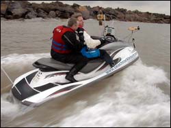
When the going gets rough the researchers (Dr John Bacon and Dr Jon Taylor from the University of East Anglia) hop on a jet ski to do bathymetric surveying – measuring the depth of a body of water – using an echo sounder and GPS to assess shifting sand levels.
Quad bikes and jet skis, as well as computer models, are being used by scientists and engineers to measure and predict storm damage.
Every winter hundreds of British homes are at risk from being flooded when storms hit our shores. Global warming is expected to make matters worse for the future.
Environmental scientists from the University of East Anglia and maritime computer modellers from the University of Liverpool have been collaborating on a project – funded by the Engineering and Physical Sciences Research Council (EPSRC) – to study the effectiveness of structures such as breakwaters (piles of rocks just off the coast) at protecting the coastline from storms. This side of the research is being carried out in the South East, which is particularly vulnerable to the effects of storms because the land here is sinking at a rate of around 1mm per year.
The research group needed to take measurements on a rapid response basis, dashing out just before a storm was forecast. To do this, the researchers used quad bikes and jet skis. They were then able to rush out and measure how much sand had been moved around by a storm. This in turn helped them to ascertain which areas had been left most vulnerable and provided unique data to test the computer models.
Field team project leader Professor Chris Vincent, Head of School and Professor of Environmental Sciences at the University of East Anglia, said: “Areas of the South East are at severe risk of disappearing and we need to understand what is happening and why. Houses and even entire towns could be lost forever if measures are not taken now to ensure their survival. We have been investigating the impact of the large breakwaters that lie just offshore along the East Anglian coast, near the village of Sea Palling in North Norfolk. We wanted to measure how much sand was moved around by each storm and where the most vulnerable places were.”
The work has led to a computer model of how winter storms are likely to affect the East Anglian coastline in the future. This will help coastal engineers improve flood defences.
Media Contact
All latest news from the category: Ecology, The Environment and Conservation
This complex theme deals primarily with interactions between organisms and the environmental factors that impact them, but to a greater extent between individual inanimate environmental factors.
innovations-report offers informative reports and articles on topics such as climate protection, landscape conservation, ecological systems, wildlife and nature parks and ecosystem efficiency and balance.


Newest articles

Sea slugs inspire highly stretchable biomedical sensor
USC Viterbi School of Engineering researcher Hangbo Zhao presents findings on highly stretchable and customizable microneedles for application in fields including neuroscience, tissue engineering, and wearable bioelectronics. The revolution in…

Twisting and binding matter waves with photons in a cavity
Precisely measuring the energy states of individual atoms has been a historical challenge for physicists due to atomic recoil. When an atom interacts with a photon, the atom “recoils” in…

Nanotubes, nanoparticles, and antibodies detect tiny amounts of fentanyl
New sensor is six orders of magnitude more sensitive than the next best thing. A research team at Pitt led by Alexander Star, a chemistry professor in the Kenneth P. Dietrich…

