NASA Sees Typhoon Rammasun Exit the Philippines
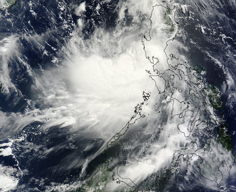
On July 16, 2014 at 02:40 Typhoon Rammasun had already crossed the Philippines and entered the South China Sea as NASA's TRMM satellite passed overhead and captured this image. Image Credit: NASA Goddard MODIS Rapid Response Team
Before Rammasun made landfall, the Tropical Rainfall Measuring Mission or TRMM satellite passed over the storm and measured cloud heights and rainfall rates. On July 14, 2014 at 18:19 UTC (2:19 p.m. EDT), TRMM spotted powerful, high thunderstorms reaching heights of almost 17km (10.5 miles).
Rain was measured falling at a rate of almost 102 mm (about 4 inches) per hour and that heavy rainfall continued as Rammasun made landfall in the central Philippines.
Rammasun made landfall near Legazpi City on July 15. Legazpi is the capital city of the province of Albay in the Philippines, located on the east coast.
On July 16, 2014 at 02:40 UTC (July 15 at 10:40 p.m. EDT) Typhoon Rammasun had already crossed the Philippines and entered the South China Sea when NASA's Terra satellite passed overhead. The Moderate Resolution Imaging Spectroradiometer or MODIS instrument provides high-resolution imagery and captured Rammasun after it moved west of Manila.
The eye of the typhoon had become obscured by clouds and was not apparent in the MODIS image. The typhoon also appeared somewhat elongated in a west-to-east direction.
On July 16 at 09:00 UTC (5 a.m. EDT), Typhoon Rammasun's maximum sustained winds were near 80 knots (92.0 mph/148.2 kph). The center was in the South China Sea, near 15.4 north latitude and 118.5 east longitude. It was about 114 nautical miles west-northwest of Manila and was moving to the northwest at 15 knots (17.2 mph/27.7 kph). The Joint Typhoon Warning Center expects Rammasun to strengthen to 105 knots (120.8 mph/194.5 kph) by July 18 before weakening again.
Typhoon Rammasun is expected to pass north of Hainan Island, China on July 18 around 0600 UTC (2 a.m. EDT). As a result, China Meteorological Administration (CMA) noted that Typhoon standby signal No 1 is expected to be raised today, July 16 as Typhoon Rammasun is expected to pass within about 500 miles (~ 800 kilometers) from Hong Kong. For current watches and warnings from CMA, visit: http://www.cma.gov.cn/en/WeatherWarnings/ActiveWarnings/201407/t20140716_252541.html.
The CMA expects Rammasun to approach the coastal area of eastern Hainan Island to western Guangxi on the mainland. Rammasun is forecast to make its next landfall at Lingshui, Hainan Island, and then in Yangjiang of the Guangdong Province of mainland China, early (local time) on July 18.
Text credit: Rob Gutro
NASA's Goddard Space Flight Center
Media Contact
More Information:
http://www.nasa.gov/content/goddard/09w-northwestern-pacific-ocean/All latest news from the category: Earth Sciences
Earth Sciences (also referred to as Geosciences), which deals with basic issues surrounding our planet, plays a vital role in the area of energy and raw materials supply.
Earth Sciences comprises subjects such as geology, geography, geological informatics, paleontology, mineralogy, petrography, crystallography, geophysics, geodesy, glaciology, cartography, photogrammetry, meteorology and seismology, early-warning systems, earthquake research and polar research.


Newest articles

Recovering phosphorus from sewage sludge ash
Chemical and heat treatment of sewage sludge can recover phosphorus in a process that could help address the problem of diminishing supplies of phosphorus ores. Valuable supplies of phosphorus could…

Efficient, sustainable and cost-effective hybrid energy storage system for modern power grids
EU project HyFlow: Over three years of research, the consortium of the EU project HyFlow has successfully developed a highly efficient, sustainable, and cost-effective hybrid energy storage system (HESS) that…

After 25 years, researchers uncover genetic cause of rare neurological disease
Some families call it a trial of faith. Others just call it a curse. The progressive neurological disease known as spinocerebellar ataxia 4 (SCA4) is a rare condition, but its…

