NASA sees Tropical Storm Andres fading RapidScat of Andres
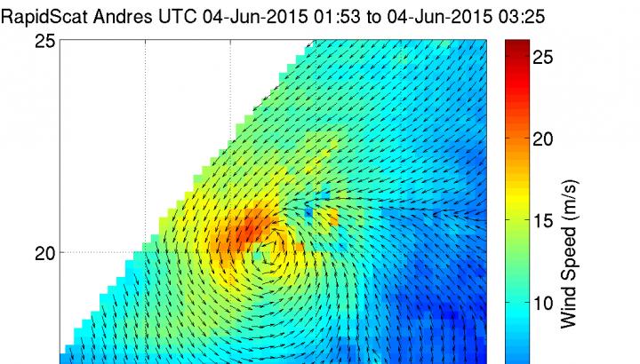
Early on June 4, RapidScat identified the strongest winds (red) in Andres were in a small area northwest of the center and as strong 25 m/s (55.9 mph/90 kph). Credits: NASA JPL, Doug Tyler
The International Space Station (ISS)-RapidScat instrument measures surface winds over the ocean. The ISS-RapidScat instrument gathered surface wind data on Tuesday, June 4 from 01:53 to 3:25 UTC (June 3 from 9:53 p.m. EDT to 11:25 p.m. EDT).
RapidScat identified the strongest winds in Andres were in a small area northwest of the center and as strong 25 meters per second (mps)/55.9 mph/90 kph. Winds surrounding the rest of the center were no stronger than 17 mps/38 mph/61 kph. At 11 a.m. EDT those tropical storm force winds extended outward up to 125 miles (205 km) from the center, according to the National Hurricane Center.
The Atmospheric Infrared Sounder or AIRS instrument that flies aboard NASA's Aqua satellite measured cloud top temperatures in Andres on June 4 at 10:11 UTC (6:11 a.m. EDT). Infrared data shows temperature, and the higher the thunderstorms and more powerful, the colder the cloud tops.
Andres cloud top temperatures had warmed, and the only thunderstorms seen in the system were pushed northeast of the center by vertical wind shear. The NHC discussion on June 4 at 11 a.m. EDT, stated that “The mid-level center of the cyclone appears to have decoupled from the low-level circulation about 12 hours ago, and only a small area of deep convection remains nearly two degrees removed from the center.”
Although Andres is weakening, it is still generating ocean swells felt along portions of the west coast of the Baja California peninsula. The National Hurricane Center (NHC) expects those swells to begin diminishing late on Thursday and Friday, June 5.
NHC noted that at 11 a.m. EDT (1500 UTC) the center of Tropical Storm Andres was located near latitude 20.1 North, longitude 124.5 West. The estimated minimum central pressure is 1003 millibars (29.62 inches). Andres was moving toward the east at 3 mph (6 kph), and a turn toward the east-southeast or southeast is expected during the next 24 hours. Maximum sustained winds had decreased to near 40 mph (65 kph) with higher gusts.
Two factors are weakening Tropical Storm Andres: strong west-southwesterly shear and cool waters. Global computer forecast models show the circulation of Andres degenerating into an open trough (elongated area of low pressure) within two to three days.
Media Contact
All latest news from the category: Earth Sciences
Earth Sciences (also referred to as Geosciences), which deals with basic issues surrounding our planet, plays a vital role in the area of energy and raw materials supply.
Earth Sciences comprises subjects such as geology, geography, geological informatics, paleontology, mineralogy, petrography, crystallography, geophysics, geodesy, glaciology, cartography, photogrammetry, meteorology and seismology, early-warning systems, earthquake research and polar research.


Newest articles

Sea slugs inspire highly stretchable biomedical sensor
USC Viterbi School of Engineering researcher Hangbo Zhao presents findings on highly stretchable and customizable microneedles for application in fields including neuroscience, tissue engineering, and wearable bioelectronics. The revolution in…

Twisting and binding matter waves with photons in a cavity
Precisely measuring the energy states of individual atoms has been a historical challenge for physicists due to atomic recoil. When an atom interacts with a photon, the atom “recoils” in…

Nanotubes, nanoparticles, and antibodies detect tiny amounts of fentanyl
New sensor is six orders of magnitude more sensitive than the next best thing. A research team at Pitt led by Alexander Star, a chemistry professor in the Kenneth P. Dietrich…

