NASA sees Tropical Cyclone Lusi over Vanuatu
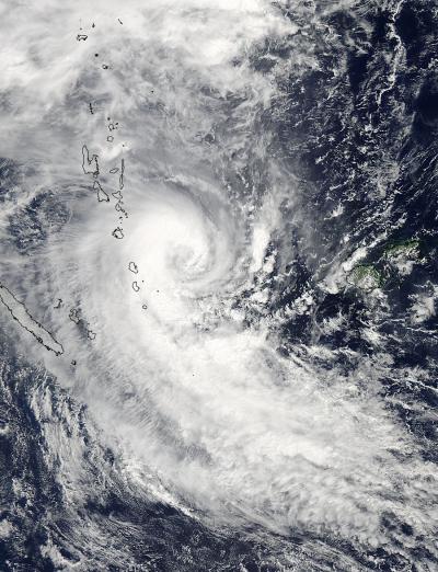
The MODIS instrument aboard NASA's Aqua satellite captured this visible image of Tropical Cyclone Lusi's western quadrant affecting Vanuatu (top left) on March 12 at 02:05 UTC. Credit: Credit: NASA Goddard MODIS Rapid Response Team
The Moderate Resolution Imaging Spectroradiometer or MODIS instrument aboard NASA's Aqua satellite captured a visible image of Tropical Cyclone Lusi that showed the storm's western quadrant affecting Vanuatu on March 12 at 02:05 UTC.
In the MODIS image, Lusi had the distinct comma shape of a mature tropical cyclone, however no eye was visible. However, animated multispectral satellite imagery does show a ragged eye with tightly curved bands of thunderstorms wrapping into it.
At 11 a.m. EDT/1500 UTC on March 12, the Vanuatu Meteorological Service's forecast noted “Heavy rain and thunder with flooding associated with [Tropical Cyclone] Lusi will continue to affect Shefa and Tafea provinces. Gale to storm clockwise winds for Shefa and Tafea province, while fresh trades prevail elsewhere.”
A Severe Weather Warning remained in effect that noted showers and thunderstorms with heavy rainfall is expected over Northern and Central Islands with inland winds of 40km/h to 50km/h. Flash flooding is also expected over low lying areas and areas close to the river banks. For updates from the Vanuatu Met Service, visit: http://www.meteo.gov.vu.
On March 12 at 0900 UTC/5 a.m. EDT, Tropical Cyclone Lusi's maximum sustained winds were at 65 knots/74.8 mph/120.4 kph. Tropical-storm-force winds extend out about 80 nautical miles/92.0 miles/148.2 km from the center.
Lusi was centered near 18.2 south latitude and 171.5 east longitude, about 395 nautical miles/454.6 miles/ 731.5 km west of Suva, Fiji. Lusi is moving to the southeast at 13 knots/14.9 mph/24.0 kph.
The Joint Typhoon Warning Center forecast calls for Lusi to intensify to 75 knots and then start to weaken on March 13 as it continues moving southward. Lusi is then expected to start transitioning into an extra-tropical storm.
Media Contact
All latest news from the category: Earth Sciences
Earth Sciences (also referred to as Geosciences), which deals with basic issues surrounding our planet, plays a vital role in the area of energy and raw materials supply.
Earth Sciences comprises subjects such as geology, geography, geological informatics, paleontology, mineralogy, petrography, crystallography, geophysics, geodesy, glaciology, cartography, photogrammetry, meteorology and seismology, early-warning systems, earthquake research and polar research.


Newest articles

Sea slugs inspire highly stretchable biomedical sensor
USC Viterbi School of Engineering researcher Hangbo Zhao presents findings on highly stretchable and customizable microneedles for application in fields including neuroscience, tissue engineering, and wearable bioelectronics. The revolution in…

Twisting and binding matter waves with photons in a cavity
Precisely measuring the energy states of individual atoms has been a historical challenge for physicists due to atomic recoil. When an atom interacts with a photon, the atom “recoils” in…

Nanotubes, nanoparticles, and antibodies detect tiny amounts of fentanyl
New sensor is six orders of magnitude more sensitive than the next best thing. A research team at Pitt led by Alexander Star, a chemistry professor in the Kenneth P. Dietrich…

