NASA Sees Tropical Cyclone Edilson Leaving Mauritius
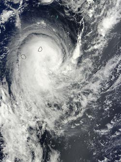
On Feb. 6 at 06:10 UTC the MODIS instrument aboard NASA's Terra satellite captured this visible image of Tropical Cyclone Edilson over Réunion and Mauritius. <br>Image Credit: NASA Goddard MODIS Rapid Response Team <br>
The Moderate Resolution Imaging Spectroradiometer instrument aboard Terra took a visible image of Edilson as its northwestern quadrant still covered the island of Mauritius. Clouds from the fringe of Edilson also blanketed La Reunion Island (located to the southwest of Mauritius).
The image showed a good rotation in the storm, with a shadowed center of circulation, hinting at the development of an eye. Microwave satellite data has also suggested the development of an eye. In addition, multi-spectral satellite imagery showed that the storm has been consolidating and there are strong curved bands of thunderstorms wrapping around the western quadrant of the storm.
Forecasters at the Joint Typhoon Warning Center expect Edilson to briefly become a hurricane over the next day.
At 1500 UTC/10 a.m. EST, Edilson's maximum sustained winds were near 55 knots/63.2 mph/101.9 kph. The tropical storm was centered near 23.3 south latitude and 57.5 east longitude, about 160 nautical miles/184.1 miles/296.3 km south-southeast of Port Louis, Mauritius. Edilson has been moving to the south-southwest at 16 knots/18.4 mph/29.6 kph.
Edilson is expected to track in a southerly direction over the next couple of days. It is forecast to move to the southwest before turning to the southeast sometime on February 9.
Text credit: Rob Gutro
NASA's Goddard Space Flight Center
Media Contact
All latest news from the category: Earth Sciences
Earth Sciences (also referred to as Geosciences), which deals with basic issues surrounding our planet, plays a vital role in the area of energy and raw materials supply.
Earth Sciences comprises subjects such as geology, geography, geological informatics, paleontology, mineralogy, petrography, crystallography, geophysics, geodesy, glaciology, cartography, photogrammetry, meteorology and seismology, early-warning systems, earthquake research and polar research.


Newest articles

Recovering phosphorus from sewage sludge ash
Chemical and heat treatment of sewage sludge can recover phosphorus in a process that could help address the problem of diminishing supplies of phosphorus ores. Valuable supplies of phosphorus could…

Efficient, sustainable and cost-effective hybrid energy storage system for modern power grids
EU project HyFlow: Over three years of research, the consortium of the EU project HyFlow has successfully developed a highly efficient, sustainable, and cost-effective hybrid energy storage system (HESS) that…

After 25 years, researchers uncover genetic cause of rare neurological disease
Some families call it a trial of faith. Others just call it a curse. The progressive neurological disease known as spinocerebellar ataxia 4 (SCA4) is a rare condition, but its…

