NASA sees strongest side of Tropical Storm Maliksi
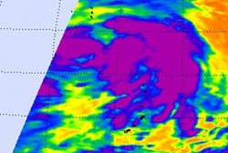
The AIRS instrument that flies aboard NASA's Aqua satellite captured an infrared image of Tropical storm Maliksi on Oct. 2, 2012, at 11:47 p.m. EDT. Strongest thunderstorms appeared east of the center of circulation, where cloud-top temperatures were as cold as -63 Fahrenheit (-52 Celsius).<br><br>Credit: NASA JPL, Ed Olsen<br>
On Oct. 3 at 1500 UTC (11 a.m. EDT), Tropical storm Maliksi had maximum sustained winds of 45 knots (51.7 mph/83.3 kph).
It was located about 470 nautical miles (541 miles/870.4 km) south-southeast of Tokyo, Japan, near 29.4 North and 143.1 East. Maliksi was speeding to the north-northeast at 21 knots (24.1 mph/38.8 kph).
The Atmospheric Infrared Sounder (AIRS) instrument that flies aboard NASA's Aqua satellite captured an infrared image of Tropical storm Maliksi on Oct. 2, 2012 at 1547 UTC (11:47 p.m. EDT). Strongest thunderstorms appeared east of the center of circulation, where cloud-top temperatures were as cold as -63 Fahrenheit (-52 Celsius).
On Oct. 3, the strongest thunderstorms and deepest convection were still only occurring east of the center of circulation, with the exception of some limited convection (rising air that form thunderstorms that make up the tropical cyclone) near the center.
The tropical storm is in an area of strong vertical wind shear, which will continue to weaken it. The Joint Typhoon Warning Center noted today, Oct. 3, that Maliksi is starting to look extra-tropical. Maliksi is forecast to remain at sea, and track to the north-northeast over the next several days during its transition.
Media Contact
More Information:
http://www.nasa.govAll latest news from the category: Earth Sciences
Earth Sciences (also referred to as Geosciences), which deals with basic issues surrounding our planet, plays a vital role in the area of energy and raw materials supply.
Earth Sciences comprises subjects such as geology, geography, geological informatics, paleontology, mineralogy, petrography, crystallography, geophysics, geodesy, glaciology, cartography, photogrammetry, meteorology and seismology, early-warning systems, earthquake research and polar research.


Newest articles

Webb captures top of iconic horsehead nebula in unprecedented detail
NASA’s James Webb Space Telescope has captured the sharpest infrared images to date of a zoomed-in portion of one of the most distinctive objects in our skies, the Horsehead Nebula….

Cost-effective, high-capacity, and cyclable lithium-ion battery cathodes
Charge-recharge cycling of lithium-superrich iron oxide, a cost-effective and high-capacity cathode for new-generation lithium-ion batteries, can be greatly improved by doping with readily available mineral elements. The energy capacity and…

Novel genetic plant regeneration approach
…without the application of phytohormones. Researchers develop a novel plant regeneration approach by modulating the expression of genes that control plant cell differentiation. For ages now, plants have been the…

