NASA Provides Satellite Views of Nor'easter Lifespan
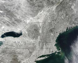
At 10:50 a.m. EST on Feb. 10, 2013, the day after the New England snowstorm, the MODIS instrument aboard NASA's Aqua satellite captured this visible image of the snow cover over the New England states, New York, New Jersey and Pennsylvania. <br><br>Credit: NASA Goddard MODIS Rapid Response Team<br>
The nor'easter dropped between 2 and 3 feet of snowfall over the U.S. Northeast and left more than 650,000 without power in eight states, according to the Associated Press. Several governors established travel bans on Saturday, Feb. 9, to promote clean-up efforts.
NOAA's GOES-13 satellite sits in a fixed orbit over the eastern United States and continually provides visible and infrared imagery of the movement of weather systems. NOAA manages the GOES satellite. The NOAA image data was compiled into an animation by NASA's GOES Project at NASA's Goddard Space Flight Center in Greenbelt, Md.
The animation runs from Feb. 6 through 9, 2013, and shows two low pressure areas move from the upper Midwest and the Gulf of Mexico and come together over the Atlantic Ocean near the Mid-Atlantic States.
The two low pressure areas formed the nor'easter that brought heavy snowfall to the U.S. Northeast. New England was the victim of a winter cold front and a Gulf-enhanced warm front merging into a classic nor'easter off the coast of New Jersey. The merged storm was held along the coast by a blocking high pressure area in eastern Canada.
A collage of GOES-13 satellite images was created at NASA Goddard and shows the development of the nor'easter over several days. GOES-13 images were captured on Feb. 7 at 1515 UTC (10:15 a.m. ET) and clearly showed two separate low pressure areas. Images on Feb. 8 at 1301 (8:01 a.m. ET) and 2045 UTC (3:45 p.m. ET) show the storms consolidating. Images captured by NOAA's GOES-13 satellite on Feb. 9 at 0201 UTC (Feb. 8 at 9:01 p.m. ET) and Feb. 9 at 1231 UTC (7:31 a.m. ET) showed the systems had merged.
According to WCVB-TV, Boston, at 7 a.m. EST on Saturday, Feb. 9, there were about 400,000 customers without power in Massachusetts. The storm had moved east by 2 p.m. EST leaving behind blue skies and gusty winds.
About 24 hours after the storm moved away from the U.S. Northeast, NASA's Aqua satellite passed overhead to capture an image of the massive snowfall. At 10:50 a.m. EST on Feb. 10, 2013, the day after the New England snowstorm, the Moderate Resolution Imaging Spectroradiometer (MODIS) instrument aboard NASA's Aqua satellite captured a visible image that showed snow cover over the New England states, New York, New Jersey and Pennsylvania. The image was created by NASA's MODIS Rapid Response Team at NASA's Goddard Space Flight Center in Greenbelt, Md.
Rob Gutro
NASA's Goddard Space Flight Center, Greenbelt, Md.
Media Contact
All latest news from the category: Earth Sciences
Earth Sciences (also referred to as Geosciences), which deals with basic issues surrounding our planet, plays a vital role in the area of energy and raw materials supply.
Earth Sciences comprises subjects such as geology, geography, geological informatics, paleontology, mineralogy, petrography, crystallography, geophysics, geodesy, glaciology, cartography, photogrammetry, meteorology and seismology, early-warning systems, earthquake research and polar research.


Newest articles

Sea slugs inspire highly stretchable biomedical sensor
USC Viterbi School of Engineering researcher Hangbo Zhao presents findings on highly stretchable and customizable microneedles for application in fields including neuroscience, tissue engineering, and wearable bioelectronics. The revolution in…

Twisting and binding matter waves with photons in a cavity
Precisely measuring the energy states of individual atoms has been a historical challenge for physicists due to atomic recoil. When an atom interacts with a photon, the atom “recoils” in…

Nanotubes, nanoparticles, and antibodies detect tiny amounts of fentanyl
New sensor is six orders of magnitude more sensitive than the next best thing. A research team at Pitt led by Alexander Star, a chemistry professor in the Kenneth P. Dietrich…

