NASA satellite sees Tropical Storm Jelawat form in northwestern Pacific
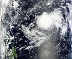
The MODIS instrument on NASA's Terra satellite captured this true-color image of Tropical Storm Jelawat on Sept. 20, 2012, at 01:50 UTC, before it had strengthened into a tropical storm. The Philippines is visible in the lower left corner.<br><br>Credit: NASA/Goddard/MODIS Rapid Response Team<br>
NASA's Terra satellite passed over Tropical Depression 18W before it strengthened into Tropical Storm Jelawat late in the day on Sept. 20, in the Philippine Sea (part of the western North Pacific Ocean basin).
On Sept. 20 at 01:50 UTC, as the depression was strengthening into a tropical storm, the Moderate Resolution Imaging Spectroradiometer (MODIS) instrument on NASA's Terra satellite captured a true-color image of the storm. The MODIS image showed a rounded shape, which indicates good circulation. There was also a band of thunderstorms east of the center of circulation.
On Sept. 21, Tropical Storm Jelawat had maximum sustained winds near 45 knots (51.7 mph/83.3 kph). Jelawat was located about 535 nautical miles east-southeast of Manila, Philippines, near 12.4 north latitude and 129.7 east longitude. It was moving to the west-southwest at 7 knots (8 mph/13 kph).
Forecasters used infrared satellite imagery, such as that from the Atmospheric Infrared Sounder instrument that flies aboard NASA's Aqua satellite to determine the initial position of the tropical storm. Infrared data from Sept. 21, 2012, showed that the strongest convection and coldest cloud top temperatures were in the northwestern and southeastern quadrants of the tropical storm. Those areas were experiencing the heaviest rainfall.
By 10 p.m. local time in Manila, Philippines (10 a.m. Eastern Time/U.S.) on Sept. 21, Jelawat's center was about 311 miles (500 km) east of Catarman capital of Northern Samar, near 12.4 north latitude and 129.7 east longitude. Northern Samar is a Philippine province in the Eastern Visayas region.
The Philippine Atmospheric Geophysical and Astronomical Services Administration issued a bulletin about Jelawat (known locally as Lawin) on Sept. 21 that noted “Estimated rainfall amount is from 10 to 25 mm (0.4 to 0.9 inches) per hour within the 600 km (373 miles) diameter of the Tropical Storm. Fishing boats and other small seacrafts are advised not to venture out into the eastern seaboard of Southern Luzon, Visayas and Mindanao due to big waves generated by Tropical Storm (Jelawat) Lawin.”
Jelawat is expected to track slowly west-northwestward over the weekend of Sept. 22 and 23 while the storm intensifies. The forecast track from the Joint Typhoon Warning Center keeps the center of Jelawat at sea, while almost tracking parallel to the Philippines.
Media Contact
More Information:
http://www.nasa.govAll latest news from the category: Earth Sciences
Earth Sciences (also referred to as Geosciences), which deals with basic issues surrounding our planet, plays a vital role in the area of energy and raw materials supply.
Earth Sciences comprises subjects such as geology, geography, geological informatics, paleontology, mineralogy, petrography, crystallography, geophysics, geodesy, glaciology, cartography, photogrammetry, meteorology and seismology, early-warning systems, earthquake research and polar research.


Newest articles

Recovering phosphorus from sewage sludge ash
Chemical and heat treatment of sewage sludge can recover phosphorus in a process that could help address the problem of diminishing supplies of phosphorus ores. Valuable supplies of phosphorus could…

Efficient, sustainable and cost-effective hybrid energy storage system for modern power grids
EU project HyFlow: Over three years of research, the consortium of the EU project HyFlow has successfully developed a highly efficient, sustainable, and cost-effective hybrid energy storage system (HESS) that…

After 25 years, researchers uncover genetic cause of rare neurological disease
Some families call it a trial of faith. Others just call it a curse. The progressive neurological disease known as spinocerebellar ataxia 4 (SCA4) is a rare condition, but its…

