NASA Satellite Sees Strength in Developing Atlantic Tropical Low
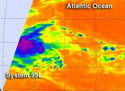
NASA's Aqua satellite passed over System 99L on August 1 at 0405 UTC (12:05 a.m. EDT) and the AIRS instrument captured an infrared image of the storm. It showed that there was a small area of strong, high, cold cloud tops of thunderstorms (purple) around the center of circulation, indicating some strength in the low pressure area.<br>Credit: NASA JPL, Ed Olsen <br>
The low pressure area, designated as “System 99L” was located about 850 miles east of the southern Windward Islands, near 10.7 North latitude and 46.9 West longitude. It was moving west between 15 and 20 mph.
NASA's Aqua satellite passed over System 99L on August 1 at 0405 UTC (12:05 a.m. EDT) and the Atmospheric Infrared Sounder (AIRS) instrument captured an infrared image of the storm.
It showed that there was a small area of strong, high, cold cloud tops of thunderstorms around the center of circulation, indicating some strength in the low pressure area. Infrared imagery shows temperature and the higher the cloud tops, the colder they are as they reach higher in the troposphere (lowest atmospheric layer).
When cloud top temperatures are very cold, it's an indication of strong uplift in the atmosphere. The cloud top temperatures around the center of this low were near -63 Fahrenheit (-52 Celsius), and indicated powerful uplift and high cloud tops.
The National Hurricane Center noted that “environmental conditions are conducive for gradual development,” and gives the storm a 70% chance of becoming a tropical depression in the next two days. Residents in the Windward Islands should monitor the progress of System 99L.
If System 99L develops into a tropical storm, it would be named “Ernesto.” The last tropical storm to form in the Atlantic Ocean this hurricane season was Debby, and she dissipated over a month ago, on June 28.
Text Credit: Rob Gutro
NASA Goddard Space Flight Center, Greenbelt, Md.
Media Contact
All latest news from the category: Earth Sciences
Earth Sciences (also referred to as Geosciences), which deals with basic issues surrounding our planet, plays a vital role in the area of energy and raw materials supply.
Earth Sciences comprises subjects such as geology, geography, geological informatics, paleontology, mineralogy, petrography, crystallography, geophysics, geodesy, glaciology, cartography, photogrammetry, meteorology and seismology, early-warning systems, earthquake research and polar research.


Newest articles

Trotting robots reveal emergence of animal gait transitions
A four-legged robot trained with machine learning by EPFL researchers has learned to avoid falls by spontaneously switching between walking, trotting, and pronking – a milestone for roboticists as well…

Innovation promises to prevent power pole-top fires
Engineers in Australia have found a new way to make power-pole insulators resistant to fire and electrical sparking, promising to prevent dangerous pole-top fires and reduce blackouts. Pole-top fires pose…

Possible alternative to antibiotics produced by bacteria
Antibacterial substance from staphylococci discovered with new mechanism of action against natural competitors. Many bacteria produce substances to gain an advantage over competitors in their highly competitive natural environment. Researchers…

