NASA Satellite Sees Sandra Strengthening at Sea
This infrared image of Cyclone Sandra was captured by the AIRS instrument that flies aboard NASA's Aqua satellite on March 8 at 1447 UTC (9:17 a.m. EST). Sandy's center and a band of thunderstorms east of center have strong (purple) thunderstorms dropping heavy rainfall. Credit: NASA JPL, Ed Olsen <br>
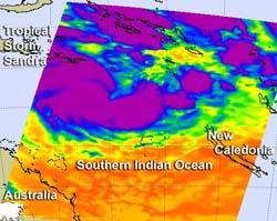
The Atmospheric Infrared Sounder (AIRS) instrument that flies aboard NASA's Aqua satellite captured an infrared image of Cyclone Sandra's cloud top temperatures on March 8 at 1717 UTC (12:17 p.m. EST). Strong thunderstorms around Sandra's center and in a band east of the center appeared as cold as -63 Fahrenheit (-52 Celsius), and are indicative of heavy rainfall.
As cloud tops grow taller in the troposphere, their temperatures grow colder (because temperatures drop with altitude in the troposphere). High cloud tops indicate a strong uplift of air that helps build the thunderstorms that make up a tropical cyclone. When uplift is strong, cloud tops sometimes punch through the top of the troposphere into the tropopause and even into the stratosphere.
Satellite imagery also showed central convection deepened (strengthened) over the storm's center since the previous day, indicating that Sandra is in a mode of strengthening.
Data from the Special Sensor Microwave Imager/Sounder (SSMIS) satellite instrument indicated an eye feature developing in Sandra early on March 8. Data from the SSMI is collected under the Defense Meteorological Satellite Program, which is a Department of Defense program responsible for designing, building, launching, and operating polar-orbiting environmental satellites.
On March 8 at 1200 UTC (7 a.m. EST/U.S.), Sandra's center was near 14.9 degrees south latitude and 157.7 degrees east longitude. The center of Cyclone Sandra was 645 nautical miles (742.3 miles/1,195 km) northwest of Noumea, New Caledonia. Sandra is moving to the east at 6 knots (7 mph/11.1 kph) and Sandra's maximum sustained winds had increased to near 60 knots (69 mph/111.1 kph).
Forecasters at the Joint Typhoon Warning Center noted on their update on March 8 that all environmental factors indicate that Sandra will continue to intensify over the next three days before weakening. Sandra is expected to pass west of New Caledonia on March 12, and bring heavy rain, possible flooding, strong winds and rough surf.
Text credit: Rob Gutro
NASA's Goddard Space Flight Center, Greenbelt, Md.
Media Contact
All latest news from the category: Earth Sciences
Earth Sciences (also referred to as Geosciences), which deals with basic issues surrounding our planet, plays a vital role in the area of energy and raw materials supply.
Earth Sciences comprises subjects such as geology, geography, geological informatics, paleontology, mineralogy, petrography, crystallography, geophysics, geodesy, glaciology, cartography, photogrammetry, meteorology and seismology, early-warning systems, earthquake research and polar research.


Newest articles

Trotting robots reveal emergence of animal gait transitions
A four-legged robot trained with machine learning by EPFL researchers has learned to avoid falls by spontaneously switching between walking, trotting, and pronking – a milestone for roboticists as well…

Innovation promises to prevent power pole-top fires
Engineers in Australia have found a new way to make power-pole insulators resistant to fire and electrical sparking, promising to prevent dangerous pole-top fires and reduce blackouts. Pole-top fires pose…

Possible alternative to antibiotics produced by bacteria
Antibacterial substance from staphylococci discovered with new mechanism of action against natural competitors. Many bacteria produce substances to gain an advantage over competitors in their highly competitive natural environment. Researchers…

