NASA Satellite Sees Pewa Become a Typhoon
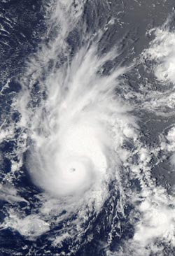
NASA's Aqua satellite passed over Typhoon Pewa on Aug. 19 at 01:05 UTC after it strengthened into a typhoon in the northwestern Pacific Ocean. The image shows that Pewa developed a small eye.<br><br>Image Credit: NASA Goddard MODIS Rapid Response<br>
On Sunday, Aug. 18, Pewa was a tropical storm when it crossed the International Date Line and moved from the Central Pacific to the Northwestern Pacific Ocean. Pewa now falls under the forecast authority of the Joint Typhoon Warning Center.
On Aug. 18, infrared satellite data showed that thunderstorm development and convection had slightly weakened, but the system remained well-organized. Forecasters at the Joint Typhoon Warning Center or JTWC, expected the slight weakening to quickly reverse itself as conditions around the storm improved. The JTWC forecast that Pewa would become a typhoon on Aug. 19, and it did.
NASA's Aqua satellite passed over Typhoon Pewa on Aug. 19 at 01:05 UTC shortly after it strengthened into a typhoon in the northwestern Pacific Ocean. The Moderate Resolution Imaging Spectroradiometer instrument image showed that Pewa developed a small eye surrounded by strong thunderstorms.
On Monday, Aug. 19 at 0900 GMT/5 a.m. EDT, Typhoon Pewa had maximum sustained winds near 65 knots/75 mph/120 kph. It was centered near 13.9 north and 177.9 east, about 726 nautical miles east-southeast of Wake Island. Pewa was moving to the northwest at 8 knots/9.2 mph/15 kph.
Pewa is expected to continue to intensify as it moves northwest. The JTWC expects Pewa to pass far to the northeast of Wake Island on Aug. 21 and 22.
Text credit: Rob Gutro
NASA's Goddard Space Flight Center
Media Contact
All latest news from the category: Earth Sciences
Earth Sciences (also referred to as Geosciences), which deals with basic issues surrounding our planet, plays a vital role in the area of energy and raw materials supply.
Earth Sciences comprises subjects such as geology, geography, geological informatics, paleontology, mineralogy, petrography, crystallography, geophysics, geodesy, glaciology, cartography, photogrammetry, meteorology and seismology, early-warning systems, earthquake research and polar research.


Newest articles

Webb captures top of iconic horsehead nebula in unprecedented detail
NASA’s James Webb Space Telescope has captured the sharpest infrared images to date of a zoomed-in portion of one of the most distinctive objects in our skies, the Horsehead Nebula….

Cost-effective, high-capacity, and cyclable lithium-ion battery cathodes
Charge-recharge cycling of lithium-superrich iron oxide, a cost-effective and high-capacity cathode for new-generation lithium-ion batteries, can be greatly improved by doping with readily available mineral elements. The energy capacity and…

Novel genetic plant regeneration approach
…without the application of phytohormones. Researchers develop a novel plant regeneration approach by modulating the expression of genes that control plant cell differentiation. For ages now, plants have been the…

