NASA's IMERG measures flooding rainfall in Peru
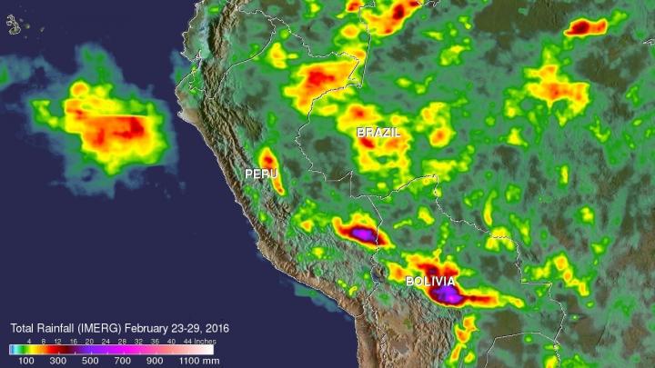
NASA's IMERG data collected from Feb. 23-29, 2016, were used to estimate rainfall totals over this area of South America. The highest rainfall total estimates for this period were over 700 mm (27.6 inches). These extreme rainfall total estimates were shown east of the Andes in southeastern Peru and Bolivia. Credits: ASA/JAXA/SSAI, Hal Pierce
GPM is the Global Precipitation Measurement mission, which is a satellite co-managed by NASA and the Japan Aerospace Exploration Agency and is used in NASA's IMERG data. GPM provides next-generation observations of rain and snow worldwide every three hours.
Extremely heavy rainfall was reported in northern Peru on February 26 and February 27, 2016. Thousands were made homeless and at least two people were reportedly killed from the severe weather. The strong El Niño was partially blamed for the abnormally high rainfall in that area.
NASA's IMERG data collected from February 23-29, 2016 were used to estimate rainfall totals over this area of South America. The highest rainfall total estimates for this period were over 700 mm (27.6 inches). These extreme rainfall total estimates were shown east of the Andes in southeastern Peru and Bolivia.
The satellites used in IMERG include DMSPs from the U.S. Department of Defense, GCOM-W from the Japan Aerospace Exploration Agency (JAXA), Megha-Tropiques from the Centre National D'etudies Spatiales (CNES) and Indian Space Research Organization (ISRO), NOAA series from the National Oceanic and Atmospheric Administration (NOAA), Suomi-NPP from NOAA-NASA, and MetOps from the European Organisation for the Exploitation of Meteorological Satellites (EUMETSAT).
All of the instruments (radiometers) onboard the constellation partners are intercalibrated with information from the GPM Core Observatory's GPM Microwave Imager (GMI) and Dual-frequency Precipitation Radar (DPR).
On March 3, Peru's National Meteorological and Hydrological Service said that rain was forecast to continue along the North Coast. The service said that in 10 hours, the Lancones (Piura) station recorded a total of 4.3 inches (110 mm), while in the city of Tumbes recorded 2.4 inches (60 mm). For forecasts, visit: http://www.
###
For more information about GPM, visit: http://www.
Media Contact
All latest news from the category: Earth Sciences
Earth Sciences (also referred to as Geosciences), which deals with basic issues surrounding our planet, plays a vital role in the area of energy and raw materials supply.
Earth Sciences comprises subjects such as geology, geography, geological informatics, paleontology, mineralogy, petrography, crystallography, geophysics, geodesy, glaciology, cartography, photogrammetry, meteorology and seismology, early-warning systems, earthquake research and polar research.


Newest articles

Recovering phosphorus from sewage sludge ash
Chemical and heat treatment of sewage sludge can recover phosphorus in a process that could help address the problem of diminishing supplies of phosphorus ores. Valuable supplies of phosphorus could…

Efficient, sustainable and cost-effective hybrid energy storage system for modern power grids
EU project HyFlow: Over three years of research, the consortium of the EU project HyFlow has successfully developed a highly efficient, sustainable, and cost-effective hybrid energy storage system (HESS) that…

After 25 years, researchers uncover genetic cause of rare neurological disease
Some families call it a trial of faith. Others just call it a curse. The progressive neurological disease known as spinocerebellar ataxia 4 (SCA4) is a rare condition, but its…

