NASA catches Tropical Depression Kajiki over central Philippines
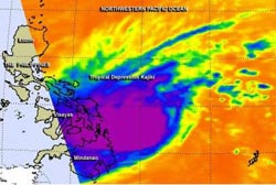
The AIRS instrument aboard NASA's Aqua satellite captured cloud top temperatures with infrared data on Tropical Depression Kajiki on Jan. 31 at 04:41 UTC, showing powerful storms (purple).<br><br>Credit: NASA JPL, Ed Olsen<br>
The Philippines have been battered by moderate to heavy rainfall over the last couple of months, and newborn Tropical Depression Kajiki, known locally in the Philippines as “Basyang” is adding to it.
At 11 a.m. EST on Friday, January 31, the airport in Leyete, Visayas, (central) Philippines reported rain with north winds sustained at 16 mph and rains from Kajiki are expected to continue on Feb. 1 as the storm continues moving west and away from Leyete.
The Philippine Atmospheric, Geophysical and Astronomical Services Administration or PAGASA has put into effect Warning Signals #1 and #2 for various areas in the Philippines.
Public Storm Warning Signal #2 is in effect in Luzon, Visayas and Mindanao. That warning calls for potential impacts of winds of 61 to 100 kph within 24 hours. Locations in the warning area include Northern Palawan, the Calamian Group of islands Aklan, Antique, Capiz, Iloilo, Guimaras, Negros, Oriental Negros, Occidental Siquijor, Cebu, Camotes Island, Bohol, Leyte, Southern Leyte, Biliran Province, Samar and Eastern Samar, Camiguin, Dinagat Province, Surigao del Norte inclunding Siargao Island, the northern part of Surigao del Sur and northern part of Agusan del Norte.
Public Storm Warning Signal #1 calls for winds between 30 and 60 kph within 36 hours. That warning is in effect for the rest of Palawan, Occidental Mindoro, Oriental Mindoro, Romblon, Masbate and Ticao Island, Northern Samar, Misamis Oriental, Misamis Occidental, rest of Agusan del Norte, rest of Surigao del Sur, Agusan del Sur, Northern part of Bukidnon, Lanao del Norte and Zamboanga del Norte.
The AIRS or Atmospheric Infrared Sounder instrument aboard NASA's Aqua satellite captured cloud top temperatures with infrared data on Tropical Depression Kajiki on Jan. 31 at 04:41 UTC, showing powerful storms around the center and western quadrants of the storm. At the time Aqua flew overhead, the western side of Kajiki was already affecting the Visayas and Mindanao regions (central and southern) of the Philippines, bringing moderate to heavy rainfall. Cloud top temperatures in those thunderstorms were at least -63F/-52C, indicating high cloud tops and strong uplift in those storms, with heavy rainfall potential.
On January 31 at 1500 UTC/10 a.m. EST, Kajiki's maximum sustained winds were near 30 knots/34.5 mph/55.5 kph. The depression was located near 9.8 north latitude and 126.1 east longitude, about 458 nautical miles/ 527.1 miles/848.2 km southeast of Manila, Philippines. Kajiki is moving to the west at 14 knots/16.1 mph/25.9 kph and is expected to track over northern Palawan on February 1 as it continues moving into the South China Sea.
Forecasters at the Joint Typhoon Warning Center expect Kajiki to dissipate over the South China Sea in several days as a result of increasing vertical wind shear and decreasing sea surface temperatures.
Media Contact
More Information:
http://www.nasa.govAll latest news from the category: Earth Sciences
Earth Sciences (also referred to as Geosciences), which deals with basic issues surrounding our planet, plays a vital role in the area of energy and raw materials supply.
Earth Sciences comprises subjects such as geology, geography, geological informatics, paleontology, mineralogy, petrography, crystallography, geophysics, geodesy, glaciology, cartography, photogrammetry, meteorology and seismology, early-warning systems, earthquake research and polar research.


Newest articles

Webb captures top of iconic horsehead nebula in unprecedented detail
NASA’s James Webb Space Telescope has captured the sharpest infrared images to date of a zoomed-in portion of one of the most distinctive objects in our skies, the Horsehead Nebula….

Cost-effective, high-capacity, and cyclable lithium-ion battery cathodes
Charge-recharge cycling of lithium-superrich iron oxide, a cost-effective and high-capacity cathode for new-generation lithium-ion batteries, can be greatly improved by doping with readily available mineral elements. The energy capacity and…

Novel genetic plant regeneration approach
…without the application of phytohormones. Researchers develop a novel plant regeneration approach by modulating the expression of genes that control plant cell differentiation. For ages now, plants have been the…

