NASA Catches Three Days of Typhoon Hagupit's Motion Over Philippines
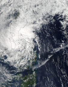
NASA's Aqua satellite captured this image on Dec. 8 at 04:50 UTC of Tropical Storm Hagupit (22W) over the Philippines. Image Credit: NASA's Goddard MODIS Rapid Response Team
The Moderate Resolution Imaging Spectroradiometer or MODIS instrument aboard NASA's Aqua satellite caught a picture of Hagupit on Dec. 6 before it made landfall. On Dec. 7, the MODIS instrument aboard NASA's Terra satellite took an image of the storm as it was making landfall in the eastern Philippines.
On Dec. 8 at 04:50 UTC (Dec. 7 at 11:50 p.m. EST) when NASA's Aqua satellite passed over the tropical cyclone again, it had weakened to a tropical storm and was located over Luzon in the northern Philippines. The image showed that Hagupit's cloud extent had grown and it covered the northern and central Philippines, extending south into Mindanao. Although the center was difficult to find in the image, it appeared that it was centered in the Sulu Sea, which lies in the middle of the Philippine islands.
On Dec. 6 at 1500 UTC (10 a.m. EST/11 p.m. local time, Manila), Tropical Storm Hagupit, known in the Philippines a Tropical Storm Ruby, had maximum sustained winds near 45 knots (51.7 mph/83.3 kph). It was centered near 13.8 north longitude and 121.3 east latitude, just 51 nautical miles (58.6 miles/94.4 km) south-southeast of Manila. It was moving to the west-northwest at 6 knots (6.9 mph/11.1 kph).
Warnings that remain in effect in the Philippines on Dec. 8 include: Public storm warning signal #2 in the following provinces: In Luzon: Metro Manila, Batangas, Cavite, Bataan, Laguna, Southern Quezon, Marinduque, Northern Oriental Mindoro including Lubang Island.
Public storm warning signal #1 remains in effect in the following provinces: Luzon: Zambales, Pampanga, Tarlac, Bulacan, Rizal, Rest of Quezon, Rest of Mindoro Provinces, Romblon. For the updated forecast from PAGASA, visit: http://pagasa.dost.gov.ph/index.php/tropical-cyclone/weather-bulletin-update
Forecasters at the Joint Typhoon Warning Center project that Hagupit's current weakening trend will continue as the storm passes into the South China Sea. Once there, unfavorable atmospheric conditions of cooler, drier air will weaken the storm further. It is expected to reach Ho Chi Minh City in southern Vietnam by Dec. 11 as a depression.
Rob Gutro
NASA's Goddard Space Flight Center
Media Contact
More Information:
http://www.nasa.gov/content/goddard/hagupit-northwestern-pacific-ocean/All latest news from the category: Earth Sciences
Earth Sciences (also referred to as Geosciences), which deals with basic issues surrounding our planet, plays a vital role in the area of energy and raw materials supply.
Earth Sciences comprises subjects such as geology, geography, geological informatics, paleontology, mineralogy, petrography, crystallography, geophysics, geodesy, glaciology, cartography, photogrammetry, meteorology and seismology, early-warning systems, earthquake research and polar research.


Newest articles

Trotting robots reveal emergence of animal gait transitions
A four-legged robot trained with machine learning by EPFL researchers has learned to avoid falls by spontaneously switching between walking, trotting, and pronking – a milestone for roboticists as well…

Innovation promises to prevent power pole-top fires
Engineers in Australia have found a new way to make power-pole insulators resistant to fire and electrical sparking, promising to prevent dangerous pole-top fires and reduce blackouts. Pole-top fires pose…

Possible alternative to antibiotics produced by bacteria
Antibacterial substance from staphylococci discovered with new mechanism of action against natural competitors. Many bacteria produce substances to gain an advantage over competitors in their highly competitive natural environment. Researchers…

