NASA's TRMM satellite sees very heavy rains in fading Tropical Storm Prapiroon
Prapiroon's winds had dropped to less than 35 knots (~40 mph) when the TRMM data were collected on Oct. 18. Despite the drop in wind speed, some powerful thunderstorms around Prapiroon's center were still reaching heights above 12 kilometers (~7.6 miles).<br><br>Credit: SSAI/NASA, Hal Pierce<br>
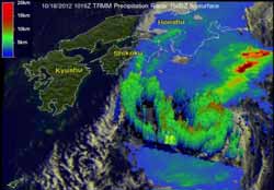
NASA's Tropical Rainfall Measuring Mission (TRMM) satellite captured rainfall data on Prapiroon twice on Oct. 18 when it passed overhead. The first orbit was at 0845UTC and the second at 1019 UTC. TRMM's Microwave Imager (TMI) and Precipitation Radar (PR) data show that rain associated with Prapiroon was falling at a rate of over 75mm/hour (~3 inches) in a feeder band northwest of the center of circulation.
Some of the rainfall occurring over Japan on Oct. 18 was being caused by a frontal system that was interacting with tropical Storm Prapiroon.
At NASA's Goddard Space Flight Center in Greenbelt, Md., Hal Pierce of the TRMM team created a 3-D image of the storm using TRMM PR data received with the 1019 UTC (6:19 a.m. EDT) orbit. Prapiroon was once a powerful typhoon with winds of 100 knots (~115 mph). Prapiroon's winds had dropped to less than 35 knots (~40 mph/65 kph) when the TRMM data were collected. Despite the drop in wind speed, some powerful thunderstorms around Prapiroon's center were still reaching heights above 12 kilometers (~7.6 miles).
By 1500 UTC on Oct. 18, Prapiroon's maximum sustained winds dropped near 35 knots (40 mph/65 kph). Tropical storm Prapiroon was, located approximately 325 nautical miles south-southwest of yokosuka, japan, near 30.9 North latitude and 138.9 East longitude. The storm has accelerated northeastward at 33 knots (38 mph/62 kph) .
Just five hours after the second TRMM satellite overpass, the Joint Typhoon Warning Center noted that “animated infrared satellite imagery showed deep central convection has unraveled and sheared north of the low level circulation center.”
Prapiroon is undergoing transitioning while battling strong wind shear and is expected to become extra-tropical by Oct. 19.
Media Contact
More Information:
http://www.nasa.govAll latest news from the category: Earth Sciences
Earth Sciences (also referred to as Geosciences), which deals with basic issues surrounding our planet, plays a vital role in the area of energy and raw materials supply.
Earth Sciences comprises subjects such as geology, geography, geological informatics, paleontology, mineralogy, petrography, crystallography, geophysics, geodesy, glaciology, cartography, photogrammetry, meteorology and seismology, early-warning systems, earthquake research and polar research.


Newest articles

Webb captures top of iconic horsehead nebula in unprecedented detail
NASA’s James Webb Space Telescope has captured the sharpest infrared images to date of a zoomed-in portion of one of the most distinctive objects in our skies, the Horsehead Nebula….

Cost-effective, high-capacity, and cyclable lithium-ion battery cathodes
Charge-recharge cycling of lithium-superrich iron oxide, a cost-effective and high-capacity cathode for new-generation lithium-ion batteries, can be greatly improved by doping with readily available mineral elements. The energy capacity and…

Novel genetic plant regeneration approach
…without the application of phytohormones. Researchers develop a novel plant regeneration approach by modulating the expression of genes that control plant cell differentiation. For ages now, plants have been the…

