NASA's Aqua Satellite Sees Small New Tropical Storm Near Tonga
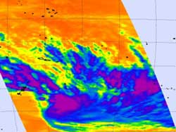
NASA's Aqua satellite captured this image of Tropical Storm 11P, on February 6, 2012 at 0053 UTC. AIRS infrared data from Aqua showed strong thunderstorms with the highest, coldest cloud tops circling the center (purple).<br>Credit: NASA/JPL, Ed Olsen <br>
NASA's Atmospheric Infrared Sounder (AIRS) instrument that flies aboard the Aqua satellite passed over the newest tropical storm in the South Pacific, Tropical Storm 11P, on February 6, 2012 at 0053 UTC (Feb. 5 at 7:53 p.m. EST). AIRS infrared data showed strong thunderstorms with the highest, coldest cloud tops circling the center.
The cloud top temperatures were colder than -63 Fahrenheit (-52.7 Celsius), indicating that some of the thunderstorms were strong. The AIRS data also showed that the storm is small, about 120 nautical miles (138 miles/222 km) in diameter, and there are bands of thunderstorms wrapping into the center of circulation.
On February 6, 2012 at 1500 UTC (10 a.m. EST), Tropical Storm 11P had maximum sustained winds near 35 knots (40.2 mph/64.8 kph). It was about 400 nautical miles (460 miles/~741 km) east of Nadi, Fiji, centered near 18.8 South latitude and 174.5 West longitude. It was moving quickly at 21 knots (~24 mph/~39 kph) to the east-southeast.
Tropical Storm 11P is approaching the main island of Tonga late on February 6. Tonga is a state and an archipelago made up of 176 islands, fifty-two of which are inhabited. It is expected to pass northeast of the main island, Tongatapu.
The Joint Typhoon Warning Center expects Tropical Storm 11P (TS11P) to speed up to the east-southeast to as fast as 30 knots (34.5 mph/55.5 kph). By February 7, TS11P is expected to encounter wind shear and cooler sea surface temperatures, two factors that will weaken it quickly. Forecasters expect that by February 9, the tropical storm will be a remnant low pressure area.
Text Credit: Rob Gutro
NASA's Goddard Space Flight Center, Greenbelt, Md.
Media Contact
All latest news from the category: Earth Sciences
Earth Sciences (also referred to as Geosciences), which deals with basic issues surrounding our planet, plays a vital role in the area of energy and raw materials supply.
Earth Sciences comprises subjects such as geology, geography, geological informatics, paleontology, mineralogy, petrography, crystallography, geophysics, geodesy, glaciology, cartography, photogrammetry, meteorology and seismology, early-warning systems, earthquake research and polar research.


Newest articles

Recovering phosphorus from sewage sludge ash
Chemical and heat treatment of sewage sludge can recover phosphorus in a process that could help address the problem of diminishing supplies of phosphorus ores. Valuable supplies of phosphorus could…

Efficient, sustainable and cost-effective hybrid energy storage system for modern power grids
EU project HyFlow: Over three years of research, the consortium of the EU project HyFlow has successfully developed a highly efficient, sustainable, and cost-effective hybrid energy storage system (HESS) that…

After 25 years, researchers uncover genetic cause of rare neurological disease
Some families call it a trial of faith. Others just call it a curse. The progressive neurological disease known as spinocerebellar ataxia 4 (SCA4) is a rare condition, but its…

