Infrared NASA Satellite Imagery Confirmed Newborn Tropical Storm Sonca
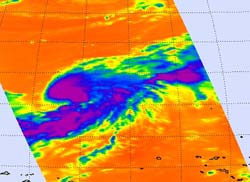
This infrared image of Tropical Storm Sonca was captured on Sept. 14 at 10:41 p.m. EDT. The purple area around the center of circulation indicates the coldest, highest cloud heights, where the heaviest rain was occurring. Satellite data also shows Sonca has taken on the signature "comma" shape of a tropical storm. Credit: NASA JPL, Ed Olsen<br>
Infrared imagery is gathered by the Atmospheric Infrared Sounder (AIRS) instrument that flies on NASA's Aqua satellite. It provides valuable information to forecast organizations such as the Joint Typhoon Warning Center and National Hurricane Center about cloud temperatures and heights and sea-surface temperatures.
Infrared data provides valuable clues about how a tropical cyclone is going to behave. High, cold clouds with temperatures colder than -63 Fahrenheit (-52 Celsius) within a tropical cyclone tell meteorologists that convection (rising air that forms thunderstorms that power a tropical cyclone) is strong, and further strengthening of the entire tropical cyclone is likely. When NASA satellites show that cloud temperatures are warming, it means there is less strength or uplift in the air to help form powerful thunderstorms.
When NASA's Aqua satellite flew over Tropical Storm Sonca on Sept. 14 at 10:41 p.m. EDT the AIRS instrument gathered that infrared temperature data about the thunderstorms that make up the storm. AIRS showed a large area around the center of circulation where the coldest, highest cloud heights, where the heaviest rain was occurring. Satellite data also showed Sonca has taken on the signature “comma” shape of a tropical storm.
Tropical Storm Sonca's maximum sustained winds are near 35 knots (40 mph) so it's just over the threshold of being a tropical storm. The storm is over 120 miles in diameter with tropical storm-force wind gusts out 60 miles from the center. Sonca is approximately 760 nautical miles east of the island of Iwo To, Japan and has tracked north-northwestward at 9 knots (10 mph).
Forecasters at the Joint Typhoon Warning Center are monitoring the progress of Sonca and using the infrared data that AIRS provides in addition data from other NASA satellites. Sonca is currently forecast to pass to the northeast of Chichi Jima, Japan over the weekend and bring gusty winds, heavy surf and rainfall to the island.
Text credit: Rob Gutro, NASA's Goddard Space Flight Center, Greenbelt, Md.
Media Contact
More Information:
http://www.nasa.govAll latest news from the category: Earth Sciences
Earth Sciences (also referred to as Geosciences), which deals with basic issues surrounding our planet, plays a vital role in the area of energy and raw materials supply.
Earth Sciences comprises subjects such as geology, geography, geological informatics, paleontology, mineralogy, petrography, crystallography, geophysics, geodesy, glaciology, cartography, photogrammetry, meteorology and seismology, early-warning systems, earthquake research and polar research.


Newest articles

Trotting robots reveal emergence of animal gait transitions
A four-legged robot trained with machine learning by EPFL researchers has learned to avoid falls by spontaneously switching between walking, trotting, and pronking – a milestone for roboticists as well…

Innovation promises to prevent power pole-top fires
Engineers in Australia have found a new way to make power-pole insulators resistant to fire and electrical sparking, promising to prevent dangerous pole-top fires and reduce blackouts. Pole-top fires pose…

Possible alternative to antibiotics produced by bacteria
Antibacterial substance from staphylococci discovered with new mechanism of action against natural competitors. Many bacteria produce substances to gain an advantage over competitors in their highly competitive natural environment. Researchers…

