Dozens of Fires Plague Oregon
Thousands of lightning strikes Sunday (7/13) and early Monday (7/14) probably started most of the wildfires, which are burning on private, public and reservation land. Dozens of fires are plaguing the forest areas in the state of Oregon.
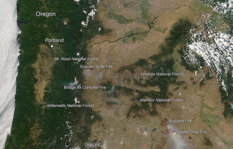
In this image, are shown the Buzzard Fire, the Shaniko Butte fire, the Bridge 99 Complex fire, and the Saddle Draw Fire.
The Buzzard Complex fire began as a lightning strike. Difficult terrain, combined with extremely dry fuels and hot and windy conditions are giving firefighters a steady challenge. Livestock, private property, several ranches, outbuildings, sage grouse habitat and agriculture lands are threatened.
At last report, one barn was lost on July 14. Heavy air tankers, single engine air tankers, helicopters, fire engines, handcrews, dozers and other equipment are on scene and will work around the clock to protect residences and limit fire spread as much as possible.
The fire is currently at 90,000 acres. The complex is made up of several different fires that span intermittently from their origins near the Lamb Ranch/Warm Springs Reservoir area south to the Beaver Table/Twin Reservoir area near Venator.
The Shaniko Butte fire began as a lightning strike on July 15, 2014. It is located fifteen miles north of Warm Springs, OR. Fueling the fire is juniper, brush, and grass. The fire has been exhibiting extreme fire behavior. Evacuations are in effect. Structures are threatened. There are 10,000 acres currently burning within this fire complex.
The Bridge 99 Complex Fire Eighteen began on July 15, 2014 with a lightning strike. The fire is eighteen miles north of Sisters, OR. Fueling the fire is mixed conifer, brush and grass.
There is active fire behavior and road closures are in effect. The fire is less than 24 hours old at this point and 300 acres have burned so far.
The Saddle Draw fire is 19 miles south of Crane, OR. Extreme fire behavior is ongoing. Residences are threatened with this fire. This is mostly a grass fed fire. Inciweb did not specify what started this particular fire.
This natural-color satellite image was collected by the Moderate Resolution Imaging Spectroradiometer (MODIS) aboard the Aqua satellite on July 15, 2014. Actively burning areas, detected by MODIS’s thermal bands, are outlined in red. NASA image courtesy Jeff Schmaltz, MODIS Rapid Response Team. Caption: NASA/Goddard, Lynn Jenner with information from Inciweb.org and http://www.nifc.gov/nicc/sitreprt.pdf
Media Contact
More Information:
http://www.nasa.gov/content/goddard/dozens-of-fires-plague-oregon/All latest news from the category: Earth Sciences
Earth Sciences (also referred to as Geosciences), which deals with basic issues surrounding our planet, plays a vital role in the area of energy and raw materials supply.
Earth Sciences comprises subjects such as geology, geography, geological informatics, paleontology, mineralogy, petrography, crystallography, geophysics, geodesy, glaciology, cartography, photogrammetry, meteorology and seismology, early-warning systems, earthquake research and polar research.


Newest articles

Combining robotics and ChatGPT
TUM professor uses ChatGPT for choreographies with flying robots. Prof. Angela Schoellig has proved that large language models can be used safely in robotics. ChatGPT develops choreographies for up to…

How the Immune System Learns from Harmless Particles
Our lungs are bombarded by all manner of different particles every single day. Whilst some are perfectly safe for us, others—known as pathogens—have the potential to make us ill. The…

Biomarkers identified for successful treatment of bone marrow tumours
CAR T cell therapy has proven effective in treating various haematological cancers. However, not all patients respond equally well to treatment. In a recent clinical study, researchers from the University…

