Three Days of NASA Infrared Images Show System 92S Tropically Developing
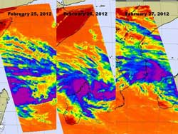
The AIRS instrument on NASA's Aqua satellite captured infrared imagery on developing System 92S in the Mozambique Channel (Indian Ocean). On February 25 at 0941 UTC, System 92S was moving west toward Madagascar. By February 26 at 10:23 UTC System 92S was over northwestern Madagascar. On February 27 at 1105 UTC had moved into the Mozambique Channel and appeared to be heading for a landfall in Mozambique.<br>Credit: NASA/JPL, Ed Olsen <br>
The Atmospheric Infrared Sounder (AIRS) instrument on NASA's Aqua satellite captured infrared imagery on developing System 92S as it moved from the Southern Indian Ocean, west across northern Madagascar and into the Mozambique Channel.
On February 25 at 0941 UTC, System 92S appeared as a rounded low pressure area with the strongest storms (and highest, coldest cloud tops on AIRS infrared imagery) south of the center of circulation. It was still in the open waters of the Southern Indian Ocean and was moving west toward Madagascar. By February 26 at 10:23 UTC System 92S was raining on northern Madagascar.
On February 27 at 1105 UTC had moved into the Mozambique Channel and appeared to be heading for a landfall in Mozambique. On the 27th, the strongest thunderstorms and coldest cloud tops appeared in two areas, north and east of the storm's center.
On February 27, the center of System 92S was located in the Mozambique Channel, near 13.5 South and 48.5 East, about 345 nautical miles north-northeast of Antananarivo, Madagascar. AIRS infrared imagery indicated that the low had weakened because of its interaction with land, as it moved over northern Madagascar.
Now that the center of System 92S is over the warm waters of the Mozambique Channel, it is expected to redevelop quickly. The area of strong thunderstorms east of center, as seen on AIRS imagery is a band of thunderstorms.
The Joint Typhoon Warning Center gives this system a high chance for developing further into a tropical cyclone in the next 24 hours.
Text Credit: Rob Gutro
NASA's Goddard Space Flight Center, Greenbelt, Md.
Media Contact
All latest news from the category: Earth Sciences
Earth Sciences (also referred to as Geosciences), which deals with basic issues surrounding our planet, plays a vital role in the area of energy and raw materials supply.
Earth Sciences comprises subjects such as geology, geography, geological informatics, paleontology, mineralogy, petrography, crystallography, geophysics, geodesy, glaciology, cartography, photogrammetry, meteorology and seismology, early-warning systems, earthquake research and polar research.


Newest articles

Sea slugs inspire highly stretchable biomedical sensor
USC Viterbi School of Engineering researcher Hangbo Zhao presents findings on highly stretchable and customizable microneedles for application in fields including neuroscience, tissue engineering, and wearable bioelectronics. The revolution in…

Twisting and binding matter waves with photons in a cavity
Precisely measuring the energy states of individual atoms has been a historical challenge for physicists due to atomic recoil. When an atom interacts with a photon, the atom “recoils” in…

Nanotubes, nanoparticles, and antibodies detect tiny amounts of fentanyl
New sensor is six orders of magnitude more sensitive than the next best thing. A research team at Pitt led by Alexander Star, a chemistry professor in the Kenneth P. Dietrich…

