Cyclone Wilma's eye catches attention of NASA satellites
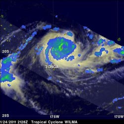
Tropical cyclone Wilma was seen by the TRMM satellite shortly after attaining hurricane intensity on Jan. 24, 2011, at 2128 UTC. The yellow and green areas indicate moderate rainfall between .78 to 1.57 inches (20 and 40 mm) per hour. Credit: NASA/SSAI, Hal Pierce<br>
On January 25 at 00:59 UTC (8:59 p.m. EST on Jan. 24), the Atmospheric Infrared Sounder (AIRS) instrument captured data that was used to create infrared and visible images at NASA's Jet Propulsion Laboratory in Pasadena, Calif. The images showed Cyclone Wilma had strengthened overnight and now has a visible eye.
AIRS Infrared imagery showed strong, very cold thunderstorm cloud tops around Wilma's center of circulation. The cloud tops were as cold as or colder than -63 Fahrenheit (-52 Celsius) indicating strong convection (rapidly rising air that creates the thunderstorms that power a tropical cyclone). Animated infrared satellite imagery showed a 25 nautical mile (29 mile/46 km) diameter ragged eye with tightly-curved banding of thunderstorms wrapping into the center.
AIRS instrument data also showed what appears to be a large “tail” from Wilma's center, stretching several hundred miles (kilometers) to the northeast of the storm's center.
Tropical cyclone Wilma was also seen by the Tropical Rainfall Measuring Mission (TRMM) satellite shortly after attaining hurricane intensity on January 24, 2011 at 2128 UTC 2:28 p.m. EST). The system had mostly moderate rainfall, falling at rates between .78 to 1.57 inches (20 and 40 mm) per hour. The TRMM satellite is managed by both NASA and JAXA, and TRMM data and imagery was created at NASA's Goddard Space Flight Center in Greenbelt, Md.
On January 25 at 0900 UTC (4 a.m. EST), Tropical Cyclone Wilma had maximum sustained winds near 85 knots (97 mph/157 km/hr). It was located about 360 nautical miles southeast of Nadi, Fiji near 22.0 South and 178.2 West. It was moving southwestward near 24 knots (27 mph/ 44 km/hr).
A Tropical Cyclone Warning is in force for areas of Tonga and for areas of Fiji. On its projected path, Tropical Cyclone Wilma is expected to pass about 124 miles (200 km) south-southeast of Ono-i-lau by midnight local time tonight.
Republic of the Fiji Islands is an island nation in Melanesia in the South Pacific Ocean about 1,243 miles (2,000 km) northeast of New Zealand's North Island. Vanuatu is located to the west, and New Caledonia is located to the southwest. Tonga is located east of Fiji. Tonga is an archipelago comprised of 176 islands scattered over 270,000 square miles (700,000 square kilometers).
Wilma is forecast to continue moving southwest parallel to Fiji and New Caledonia as it makes its way toward New Zealand. On January 28 it is forecast to change course and head southeast bringing rains and gusty winds to northern New Zealand.
Media Contact
More Information:
http://www.Nasa.govAll latest news from the category: Earth Sciences
Earth Sciences (also referred to as Geosciences), which deals with basic issues surrounding our planet, plays a vital role in the area of energy and raw materials supply.
Earth Sciences comprises subjects such as geology, geography, geological informatics, paleontology, mineralogy, petrography, crystallography, geophysics, geodesy, glaciology, cartography, photogrammetry, meteorology and seismology, early-warning systems, earthquake research and polar research.


Newest articles

After 25 years, researchers uncover genetic cause of rare neurological disease
Some families call it a trial of faith. Others just call it a curse. The progressive neurological disease known as spinocerebellar ataxia 4 (SCA4) is a rare condition, but its…

Lower dose of mpox vaccine is safe
… and generates six-week antibody response equivalent to standard regimen. Study highlights need for defined markers of mpox immunity to inform public health use. A dose-sparing intradermal mpox vaccination regimen…

Efficient, sustainable and cost-effective hybrid energy storage system for modern power grids
EU project HyFlow: Over three years of research, the consortium of the EU project HyFlow has successfully developed a highly efficient, sustainable, and cost-effective hybrid energy storage system (HESS) that…

