The cold power of Hurricane Gilma revealed by NASA satellite
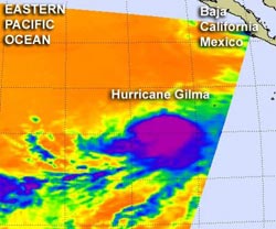
NASA's Aqua satellite passed over Hurricane Gilma on Aug. 9 at 5:53 a.m. EDT. The AIRS instrument captured an infrared image of the cloud temperatures that showed the strongest storms (purple) and heaviest rainfall was wrapped around the storm's center.<br><br>Credit: NASA JPL, Ed Olsen<br>
NASA's Aqua satellite passed over Hurricane Gilma on August 9 at 5:53 a.m. EDT. The Atmospheric Infrared Sounder (AIRS) instrument captured an infrared image of the cloud temperatures that showed the strongest storms and heaviest rainfall were wrapped around the storm's center.
Cloud top temperatures in that area were as cold as -63 Fahrenheit (-52 Celsius), indicating very strong thunderstorms (a tropical cyclone is made up of hundreds of thunderstorms), with potentially heavy rainfall. The higher a cloud top extends into the atmosphere, the colder it is, and that data is picked up by the AIRS instrument onboard the Aqua satellite.
On August 9, 2012 at 11 a.m. EDT (8 a.m. PDT) Gilma's maximum sustained winds are near 75 mph (120 kmh), down from 80 mph (130 kmh) which makes Gilma a category one hurricane on the Saffir-Simpson Hurricane wind scale. Gilma was far from land and its center was about 715 miles (1,155 km) southwest of the southern tip of Baja California, near latitude 16.2 north and longitude 118.6 west. Gilma is moving toward the west-northwest near 7 mph (11 kmh). Forecasters expect Gilma to turn to the northwest because a ridge of high pressure that has been guiding it is now weakening.
The National Hurricane Center expects Gilma to start weakening over the next day as it moves into an area of cooler waters. AIRS also provides temperature data on sea surface temperatures, and has observed declining temperatures north of Gilma's current location in the Eastern Pacific Ocean. Waters of 80 degrees Fahrenheit (26.6 Celsius) are needed to maintain a tropical cyclone, and Gilma is headed for waters cooler than that over the next couple of days.
Watching Two Other Areas
Forecasters at the National Hurricane Center (NHC) are now watching two additional areas of low pressure to the east of Gilma. The first area is several hundred miles south-southwest of Acapulco, Mexico. The NHC gives this low a meager 10 percent chance of development in the next two days because it appeared more disorganized today on satellite imagery. The second area is a trough (elongated area) of low pressure along Mexico's west coast. That low may interact with Tropical Storm Ernesto which is poised to cross from the Gulf of Mexico into the Pacific. However, because of upper level winds, this low pressure area also has a 10 percent chance of development in the next two days.
Media Contact
More Information:
http://www.nasa.govAll latest news from the category: Earth Sciences
Earth Sciences (also referred to as Geosciences), which deals with basic issues surrounding our planet, plays a vital role in the area of energy and raw materials supply.
Earth Sciences comprises subjects such as geology, geography, geological informatics, paleontology, mineralogy, petrography, crystallography, geophysics, geodesy, glaciology, cartography, photogrammetry, meteorology and seismology, early-warning systems, earthquake research and polar research.


Newest articles

Recovering phosphorus from sewage sludge ash
Chemical and heat treatment of sewage sludge can recover phosphorus in a process that could help address the problem of diminishing supplies of phosphorus ores. Valuable supplies of phosphorus could…

Efficient, sustainable and cost-effective hybrid energy storage system for modern power grids
EU project HyFlow: Over three years of research, the consortium of the EU project HyFlow has successfully developed a highly efficient, sustainable, and cost-effective hybrid energy storage system (HESS) that…

After 25 years, researchers uncover genetic cause of rare neurological disease
Some families call it a trial of faith. Others just call it a curse. The progressive neurological disease known as spinocerebellar ataxia 4 (SCA4) is a rare condition, but its…

