Citizen scientists map global forests
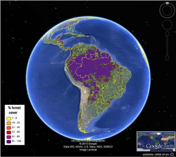
A view of South America's forest cover from the new hybrid global forest map, viewed via the Geo-Wiki platform IIASA/Geo-wiki/Google Earth
New maps of global forest cover from IIASA’s Geo-Wiki team provide a more accurate view of global forests. The maps were published in the journal Remote Sensing of the Environment, and are freely available for exploration and download on the Geo-Wiki Web site.
While there are many existing sources of data about forests, including satellite imagery, there is broad disagreement between the data products. Knowing the location and extent of forests is vital information for ecology, climate change, and economic modelling, as well as for researchers looking for the best reference information to estimate deforestation and forest degradation.
“The new maps rely on a combination of recent multisensory remote sensing data, statistics, and crowdsourcing,” says Dmitry Schepaschenko, the lead author of the study. “By combining different data sources, and incorporating the input of trained citizen scientists, we were able to produce new maps that are more accurate than any existing data source.”
The study introduces two global forest maps, both at 1-kilometer resolution, which provide a good compromise between the level of detail and global coverage. The first, which the researchers call the “best-guess” map, uses 8 different data sources and relied on a network of citizen scientists to check or validate the classification of land cover, by looking at high-resolution satellite imagery of different locations. Compared to existing data products, the researchers found, the new hybrid map was more accurate both for forest location and estimation of percentage forest cover.
The second map was further calibrated using regional and country-level forest statistics from the Food and Agriculture Organization (FAO). Schepaschenko explains that this makes the map more useful for economic modeling, and notes that such data are also used as inputs to international climate negotiations.
This also represents the first forest map that is consistent with FAO statistics and is freely available. A comparison of the two maps (i.e. the “best guess” and the calibrated one) highlights the countries where there are discrepancies and hence raises questions about reporting.
The new maps were produced for the year 2000 as a base year for modeling. The team also plans to update them with data for 2010 in the near future.
The new maps will be useful not only for research, but also for policymakers who rely on forest data for planning and decision making purposes. For example, past research has shown that estimates of the efforts required to reach the European Union’s biofuel target vary widely depending on which forest map was selected as an input.
The new maps complement another set of global cropland and land cover maps from the Geo-Wiki team and network, which were published earlier this year. “These new maps just go to show that regular people, in their free time, can contribute to top quality research,” says Schepaschenko.
IIASA researcher and study co-author Linda See adds “Geo-Wiki and our network of volunteers continue to help us improve land cover and develop robust products for the modelling and policy communities.”
Reference
Schepaschenko D., et al. (2015). Development of a global hybrid forest mask through the synergy of remote sensing, crowdsourcing and FAO statistics. Remote Sensing of Environment 162 (2015) 208–220 http://dx.doi.org/10.1016/j.rse.2015.02.011
http://www.iiasa.ac.at/web/home/about/news/150330-ForestMap.html
http://www.geo-wiki.org
Media Contact
All latest news from the category: Earth Sciences
Earth Sciences (also referred to as Geosciences), which deals with basic issues surrounding our planet, plays a vital role in the area of energy and raw materials supply.
Earth Sciences comprises subjects such as geology, geography, geological informatics, paleontology, mineralogy, petrography, crystallography, geophysics, geodesy, glaciology, cartography, photogrammetry, meteorology and seismology, early-warning systems, earthquake research and polar research.


Newest articles

Trotting robots reveal emergence of animal gait transitions
A four-legged robot trained with machine learning by EPFL researchers has learned to avoid falls by spontaneously switching between walking, trotting, and pronking – a milestone for roboticists as well…

Innovation promises to prevent power pole-top fires
Engineers in Australia have found a new way to make power-pole insulators resistant to fire and electrical sparking, promising to prevent dangerous pole-top fires and reduce blackouts. Pole-top fires pose…

Possible alternative to antibiotics produced by bacteria
Antibacterial substance from staphylococci discovered with new mechanism of action against natural competitors. Many bacteria produce substances to gain an advantage over competitors in their highly competitive natural environment. Researchers…

