Category 2 Hurricane Miriam Seen in E. Pacific by NASA Satellite
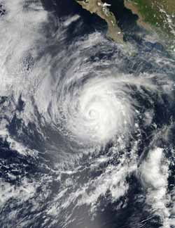
NASA's Aqua satellite flew over Hurricane Miriam on Sept. 24 at 21:00 UTC and the MODIS instrument captured this image off Mexico's west coast. (Credit: NASA/Goddard/MODIS Rapid Response Team.)<br>
MODIS stands for the Moderate Resolution Imaging Spectroradiometer. Terra's MODIS and Aqua's MODIS view the entire Earth's surface every 1 to 2 days, acquiring data in 36 spectral bands, or groups of wavelengths.
NASA's Aqua satellite flew over Hurricane Miriam on Sept. 24 at 21:00 UTC and the MODIS instrument captured a visible image of Hurricane Miriam off Mexico's west coast.
The MODIS image showed that Miriam's eye was covered by high clouds, yet the eye is still about 30 nautical miles wide. Cloud top temperatures around the eye have cooled in infrared imagery, which indicates thunderstorms around the eye still have strong uplift and are shooting high into the troposphere.
On Sept. 25 at 5 a.m. EDT Hurricane Miriam's maximum sustained winds were near 105 mph (165 kmh), making it a category 2 hurricane on the Saffir-Simpson hurricane scale. Miriam 's hurricane-force winds extend only 30 miles (45 km) from the center. Slow weakening is forecast during the next 48 hours, according to the National Hurricane Center.
Miriam's center was located near latitude 18.7 north and longitude 114.3 west. Miriam is moving in a northwesterly direction near 6 mph (9 kmh) and is expected to turn to the north-northwest later on Sept. 25, followed by a turn to the north. Miriam's estimated minimum central pressure is 968 millibars.
Although Miriam is off-shore, the hurricane is producing very rough seas along the south and western coasts of the central Baja Peninsula, and those conditions will continue for the next several days.
Text credit: Rob Gutro
NASA's Goddard Space Flight Center, Greenbelt, Md.
Media Contact
All latest news from the category: Earth Sciences
Earth Sciences (also referred to as Geosciences), which deals with basic issues surrounding our planet, plays a vital role in the area of energy and raw materials supply.
Earth Sciences comprises subjects such as geology, geography, geological informatics, paleontology, mineralogy, petrography, crystallography, geophysics, geodesy, glaciology, cartography, photogrammetry, meteorology and seismology, early-warning systems, earthquake research and polar research.


Newest articles

Sea slugs inspire highly stretchable biomedical sensor
USC Viterbi School of Engineering researcher Hangbo Zhao presents findings on highly stretchable and customizable microneedles for application in fields including neuroscience, tissue engineering, and wearable bioelectronics. The revolution in…

Twisting and binding matter waves with photons in a cavity
Precisely measuring the energy states of individual atoms has been a historical challenge for physicists due to atomic recoil. When an atom interacts with a photon, the atom “recoils” in…

Nanotubes, nanoparticles, and antibodies detect tiny amounts of fentanyl
New sensor is six orders of magnitude more sensitive than the next best thing. A research team at Pitt led by Alexander Star, a chemistry professor in the Kenneth P. Dietrich…

