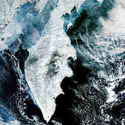
Double volcanic eruption in Eastern Russia

Acquired from orbit 800 kilometres away, this Envisat image shows two volcanoes erupting simultaneously on Russia’s snowy Kamchatka Peninsula this week.
Located in the Russian Far East, the Kamchatka Peninsula is a landscape covered with volcanoes, part of the Pacific ’Ring of Fire’. Two stratovolcanoes, Kliuchevskoi and Shiveluch are currently erupting simultaneously.
The more southerly 4835-metre-high Kliuchevskoi volcano began its latest eruption on 17 January 2005. By 7 March its consequent lava flow had reached the Erman glacier and started to melt it, causing a threat of potential mudslides. The hot volcanic material in contact with the surrounding ice and snow caused secondary explosions, hurling material as far as eight kilometres into the air.
Above it is Kamchatka’s most northerly active volcano Shiveluch – also known as Sheveluch. It is 3283 metres high and started its latest eruption on 27 February 2005. The erupting material covers an area over 700 kilometres across with a layer of ash about 150 kilometres wide and eight centimetres thick, extending westward to the Okhotsk Sea. A ten-km-wide lava flow destroyed the Shiveluch seismological station, located about eight km from the volcano.
Russia’s Novosti RIA news agency reports that the village of Klyuchi located between the two volcanoes is suffering periodic ash falls but is otherwise safe. Aviation is at greater threat, with volcanic ash particles capable of disabling aircraft engines: Kamchatka is on a major airline route, and aircraft have had to divert around eruptions in the past.
The image was acquired by Envisat’s Medium Resolution Imaging Spectrometer (MERIS) in Reduced Resolution Mode, with a spatial resolution of 300 metres and a width of 1284 km. It was processed for ESA by Brockmann Consult.
Media Contact
More Information:
http://www.esa.int/export/esaEO/SEMUVXO256E_planet_0.htmlAll latest news from the category: Earth Sciences
Earth Sciences (also referred to as Geosciences), which deals with basic issues surrounding our planet, plays a vital role in the area of energy and raw materials supply.
Earth Sciences comprises subjects such as geology, geography, geological informatics, paleontology, mineralogy, petrography, crystallography, geophysics, geodesy, glaciology, cartography, photogrammetry, meteorology and seismology, early-warning systems, earthquake research and polar research.
Newest articles

A universal framework for spatial biology
SpatialData is a freely accessible tool to unify and integrate data from different omics technologies accounting for spatial information, which can provide holistic insights into health and disease. Biological processes…

How complex biological processes arise
A $20 million grant from the U.S. National Science Foundation (NSF) will support the establishment and operation of the National Synthesis Center for Emergence in the Molecular and Cellular Sciences (NCEMS) at…

Airborne single-photon lidar system achieves high-resolution 3D imaging
Compact, low-power system opens doors for photon-efficient drone and satellite-based environmental monitoring and mapping. Researchers have developed a compact and lightweight single-photon airborne lidar system that can acquire high-resolution 3D…


