NASA sees Tropical Storm Chantal's heavy rainfall and towering thunderstorms

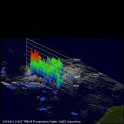
NASA's TRMM satellite showed that the most intense rain falling in Tropical Storm Chantal on July 8 was falling at a rate of over 115.5 mm/hr. (~4.5 inches) near Chantal's center of circulation.<br><br>Credit: NASA/SSAI, Hal Pierce<br>
Later in the day at 1700 UTC (1 p.m. EDT) on July 8, the Moderate Resolution Imaging Spectroradiometer or MODIS instrument that flies aboard NASA's Aqua satellite captured a visible image of Tropical Storm Chantal. The image showed the Chantal continued to organize as it moves through the Caribbean Sea. Tropical storm force winds extend outward up to 90 miles (150 km) mainly to the north of the center, but the extent of the cloud cover appears larger in visible imagery.
As of 8 a.m. EDT on July 9, a tropical storm warning was in effect for: Barbados, Dominica, St Lucia, Martinique, Guadeloupe, Puerto Rico and southern coast of the Dominican Republic from Cabo Engano to the border with Haiti. In addition, a tropical storm watch was in effect for the U.S. Virgin Islands, Saint Vincent, Vieques and Culebra, Haiti, the northern coast of the Dominican Republic, Turks and Caicos and the southeastern Bahamas.
The National Hurricane Center (NHC) noted that a storm surge of 1 to 3 feet above normal tidal levels can be expected in the Windward and Leeward Islands and Puerto Rico. Along the southern coast of the Dominican Republic, the surge is expected to be higher, reaching 2 to 4 feet. The heavy rainfall that NASA's TRMM satellite observed can be expected over the Leeward and Windward Islands, with totals between 2 to 4 inches, and isolated totals to 6 inches.
NHC expects tropical storm conditions are expected to affect portions of Windward Islands today, July 9, and Puerto Rico tonight or early Wednesday.
At 8 a.m. EDT Chantal's maximum sustained winds were near 50 mph (85 kph). NHC expects some strengthening. Chantal was centered near 13.8 north latitude and 59.7 west longitude, just 45 miles (70 km) north-northwest of Barbados, and 85 miles east of St. Lucia. Chantal was moving to the west-northwest at a speedy 26 mph (43 kph), and is expected to continue in that general direction for the next couple of days. Minimum central pressure is near 1010 millibars.
Chantal's center is expected to move into the eastern Caribbean Sea during the afternoon and evening of July 9 and near the Dominican Republic by July 10. Current forecast tracks from the NHC bring Chantal along the eastern coast of Florida by the weekend of July 13 and 14.
Media Contact
More Information:
http://www.nasa.govAll latest news from the category: Earth Sciences
Earth Sciences (also referred to as Geosciences), which deals with basic issues surrounding our planet, plays a vital role in the area of energy and raw materials supply.
Earth Sciences comprises subjects such as geology, geography, geological informatics, paleontology, mineralogy, petrography, crystallography, geophysics, geodesy, glaciology, cartography, photogrammetry, meteorology and seismology, early-warning systems, earthquake research and polar research.
Newest articles

A universal framework for spatial biology
SpatialData is a freely accessible tool to unify and integrate data from different omics technologies accounting for spatial information, which can provide holistic insights into health and disease. Biological processes…

How complex biological processes arise
A $20 million grant from the U.S. National Science Foundation (NSF) will support the establishment and operation of the National Synthesis Center for Emergence in the Molecular and Cellular Sciences (NCEMS) at…

Airborne single-photon lidar system achieves high-resolution 3D imaging
Compact, low-power system opens doors for photon-efficient drone and satellite-based environmental monitoring and mapping. Researchers have developed a compact and lightweight single-photon airborne lidar system that can acquire high-resolution 3D…


