NASA sees remnants of Cyclone Tim fading near southeastern Queensland

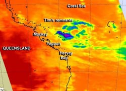
This infrared image of Cyclone Tim was captured on March 18 at 0355 UTC (March 17 at 11:55 p.m. EDT) by the AIRS instrument aboard NASA's Aqua satellite. The coldest cloud top temperatures and strongest thunderstorms appear in small area of purple off shore from southeastern Queensland.<br><br>Credit: NASA JPL, Ed Olsen<br>
The Atmospheric Infrared Sounder (AIRS) instrument aboard NASA's Aqua satellite captured an infrared image of Cyclone Tim on March 18 at 0355 UTC (March 17 at 11:55 p.m. EDT). The AIRS image showed that cloud top temperatures had warmed significantly since the previous day as the low pressure area continues to weaken. The coldest cloud top temperatures and strongest thunderstorms appeared in small area offshore from southeastern Queensland.
On March 18 at 1200 UTC (8 a.m. EDT/10 p.m. local time, Brisbane, Queensland, Australia), the remnants of ex-cyclone Tim was located near 19.1 south latitude and 151.7 east longitude, was located about 190 nautical miles (218.6 miles/ 352 km) northeast of Mackay. Tim's remnants were drifting west at 2 knots (2.3 mph/3.7 kph). The Australian Bureau of Meteorology (ABOM) noted that Tim's remnants are causing rough to very rough seas and moderate south to southeasterly swell. According to ABOM, wind gusts to 40 knots (46 mph/74 kph) are possible from Tim's remnants.
As a result of Tim's close proximity to the Queensland coast, several warnings were posted on March 18 at 2:15 p.m. EDT/U.S. (12:15 a.m. local time, Brisbane on Tuesday, March 19). A Gale Warning is in effect from Townsville to Bowen and from Bowen to Yeppoon, Strong Wind Warnings are in effect from Cardwell to Townsville and from Yeppoon to Double Island Point, including Hervey Bay. A Coastal Waters Wind Warning was also posted for Cardwell to Double Island Point, including Hervey Bay.
ABOM expects Tim's remnants to move in a west-northwest direction towards the Queensland coast over the next few days.
Media Contact
More Information:
http://www.nasa.govAll latest news from the category: Earth Sciences
Earth Sciences (also referred to as Geosciences), which deals with basic issues surrounding our planet, plays a vital role in the area of energy and raw materials supply.
Earth Sciences comprises subjects such as geology, geography, geological informatics, paleontology, mineralogy, petrography, crystallography, geophysics, geodesy, glaciology, cartography, photogrammetry, meteorology and seismology, early-warning systems, earthquake research and polar research.
Newest articles

A universal framework for spatial biology
SpatialData is a freely accessible tool to unify and integrate data from different omics technologies accounting for spatial information, which can provide holistic insights into health and disease. Biological processes…

How complex biological processes arise
A $20 million grant from the U.S. National Science Foundation (NSF) will support the establishment and operation of the National Synthesis Center for Emergence in the Molecular and Cellular Sciences (NCEMS) at…

Airborne single-photon lidar system achieves high-resolution 3D imaging
Compact, low-power system opens doors for photon-efficient drone and satellite-based environmental monitoring and mapping. Researchers have developed a compact and lightweight single-photon airborne lidar system that can acquire high-resolution 3D…


