Earth from Space: Hurricane Jimena

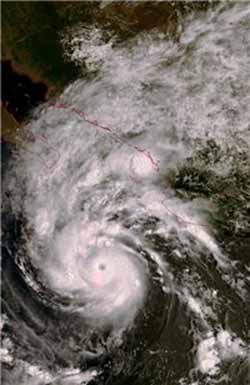
This Envisat image captures Hurricane Jimena roaring towards Mexico\'s Baja California Peninsula on 31 August 2009 (18:09 UT). Around the time of the acquisition, Jimena had maximum sustained winds of nearly 250 km/h and was just short of being classified as a Category 5 storm – the highest danger rating for a hurricane on the Saffir–Simpson intensity scale. Instruments aboard ESA’s Envisat allow it to observe various features of hurricanes, including cloud structure, wind and wave fields, sea-surface temperature and sea-surface height. Envisat’s Medium Resolution Imaging Spectrometer (MERIS) optical instrument acquired this image working in Full Resolution mode to provide a spatial resolution of 300 m. Credits: ESA
Around the time of the acquisition, Jimena had maximum sustained winds of nearly 250 km/h and was just short of being classified as a Category 5 storm – the highest danger rating for a hurricane on the Saffir–Simpson intensity scale.
By early Wednesday 2 September, it had weakened to a Category 2 hurricane as its maximum wind speed dropped to 165 km/h, according to the US National Hurricane Center. Later on Wednesday, it was downgraded again to a Category 1 hurricane after its maximum sustained winds decreased to 145 km/h.
The hurricane, which formed on 29 August in the eastern Pacific Ocean, weakened to a tropical storm later on Wednesday after making landfall on the Baja California Peninsula (left). The peninsula lies at the southern tip of North America and is surrounded by water with the Gulf of California, also called the Sea of Cortés, to the east and the Pacific Ocean to the west. Mainland Mexico is visible across the top of the image.
Hurricanes are large powerful storms that rotate around a central area of extreme low pressure. They arise in warm tropical waters that transfer their heat to the air. The warmed air rises rapidly, in the process creating low pressure at the water surface. Winds begin rushing inwards and upwards around this low-pressure zone.
Knowing the strength and path of hurricanes is critical for issuing timely warnings. Earth observation satellites are the best means of providing data on the forces that power the storm.
Instruments aboard ESA’s Envisat allow it to observe various features of hurricanes, including cloud structure, wind and wave fields, sea-surface temperature and sea-surface height. Envisat’s Medium Resolution Imaging Spectrometer (MERIS) optical instrument acquired this image working in Full Resolution mode to provide a spatial resolution of 300 m.
Media Contact
More Information:
http://www.esa.int/esaEO/SEMDBEFF5ZF_index_0.htmlAll latest news from the category: Physics and Astronomy
This area deals with the fundamental laws and building blocks of nature and how they interact, the properties and the behavior of matter, and research into space and time and their structures.
innovations-report provides in-depth reports and articles on subjects such as astrophysics, laser technologies, nuclear, quantum, particle and solid-state physics, nanotechnologies, planetary research and findings (Mars, Venus) and developments related to the Hubble Telescope.
Newest articles

After 25 years, researchers uncover genetic cause of rare neurological disease
Some families call it a trial of faith. Others just call it a curse. The progressive neurological disease known as spinocerebellar ataxia 4 (SCA4) is a rare condition, but its…

Lower dose of mpox vaccine is safe
… and generates six-week antibody response equivalent to standard regimen. Study highlights need for defined markers of mpox immunity to inform public health use. A dose-sparing intradermal mpox vaccination regimen…

Efficient, sustainable and cost-effective hybrid energy storage system for modern power grids
EU project HyFlow: Over three years of research, the consortium of the EU project HyFlow has successfully developed a highly efficient, sustainable, and cost-effective hybrid energy storage system (HESS) that…


