The Medusa Fossae formation on Mars
Medusa Fossae formation as seen by Mars Express
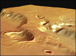
These images, taken by the High Resolution Stereo Camera (HRSC) on board ESA’s Mars Express spacecraft, show part of the Medusa Fossae formation and adjacent areas at the highland-lowland boundary on Mars.
The HRSC obtained these images during orbit 917 with a resolution of approximately 13 metres per pixel. The scenes show an area located at about 5º South and 213º East.
The Medusa Fossae formation is an extensive unit of enigmatic origin found near the Martian ‘highland-lowland dichotomy boundary’ between the Tharsis and Elysium centres of volcanic activity. This dichotomy boundary is a narrow region separating the cratered highlands, located mostly in the southern hemisphere of Mars, from the northern hemisphere’s lowland plains.
The cratered highlands stand two to five kilometres higher than the lowland plains, so the boundary is a relatively steep slope. The processes that created and modified the dichotomy boundary remain among the major unanswered issues in Mars science.
The boundary between the old volcanic plateau region and part of the widespread deposits of the Medusa Fossae formation, called Amazonis Sulci, is shown in this image. In general, the formation appears as a smooth and gently undulating surface, but is partially wind-sculpted into ridges and grooves, as shown in the mosaic of nadir images.
It is commonly agreed that the materials forming Medusa Fossae were deposited by pyroclastic flows or similar volcanic ash falls. The plateau walls of the volcanic massif are partly covered by lava flows and crossed in places by valleys which were most likely carved by fluvial activity.
The remains of water-bearing inner channels are visible in the centre of the valleys and at the bottom of the massif. Superposition of the lobe-fronted pyroclastic flows indicates that the water erosion ended before their deposition. Later, a ‘bolide’ impacted near the massif and the ejecta blanket was spread as a flow over parts of the plateau, implying water or ice was present in the subsurface at the time of impact.
A bolide is any extraterrestrial body in the 1-10 kilometre size range, which impacts on a planetary surface, explodes on impact and creates a large crater. This is a generic term, used when we do not know the precise nature of the impacting body, whether it is a rocky or metallic asteroid, or an icy comet, for example.
The colour images have been derived from the three HRSC colour channels and nadir channel. The perspective views have been calculated from the digital terrain model derived from the stereo channels. The anaglyph image was calculated from the nadir and one stereo channel. Image resolution has been decreased for use on the internet.
Media Contact
More Information:
http://www.esa.int/SPECIALS/Mars_Express/SEMSSZRMD6E_0.htmlAll latest news from the category: Physics and Astronomy
This area deals with the fundamental laws and building blocks of nature and how they interact, the properties and the behavior of matter, and research into space and time and their structures.
innovations-report provides in-depth reports and articles on subjects such as astrophysics, laser technologies, nuclear, quantum, particle and solid-state physics, nanotechnologies, planetary research and findings (Mars, Venus) and developments related to the Hubble Telescope.


Newest articles

A universal framework for spatial biology
SpatialData is a freely accessible tool to unify and integrate data from different omics technologies accounting for spatial information, which can provide holistic insights into health and disease. Biological processes…

How complex biological processes arise
A $20 million grant from the U.S. National Science Foundation (NSF) will support the establishment and operation of the National Synthesis Center for Emergence in the Molecular and Cellular Sciences (NCEMS) at…

Airborne single-photon lidar system achieves high-resolution 3D imaging
Compact, low-power system opens doors for photon-efficient drone and satellite-based environmental monitoring and mapping. Researchers have developed a compact and lightweight single-photon airborne lidar system that can acquire high-resolution 3D…

