Titan, close and in false colour
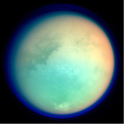
This image shows Titan in ultraviolet and infrared wavelengths, taken by the NASA/ESA/ASI Cassini-Huygens spacecraft on 26 October 2004, during the close fly-by.
This image is constructed from four images acquired through different colour filters. Red and green colours represent infrared wavelengths and show areas where atmospheric methane absorbs light.
These colours reveal a brighter (redder) northern hemisphere. Blue represents ultraviolet wavelengths and shows the high atmosphere and detached hazes.
Titan has a gigantic atmosphere, extending hundreds of kilometres above the surface. The sharp variations in brightness on Titan’s surface (and clouds near the south pole) are apparent at infrared wavelengths.
Media Contact
More Information:
http://www.esa.intAll latest news from the category: Physics and Astronomy
This area deals with the fundamental laws and building blocks of nature and how they interact, the properties and the behavior of matter, and research into space and time and their structures.
innovations-report provides in-depth reports and articles on subjects such as astrophysics, laser technologies, nuclear, quantum, particle and solid-state physics, nanotechnologies, planetary research and findings (Mars, Venus) and developments related to the Hubble Telescope.


Newest articles

A universal framework for spatial biology
SpatialData is a freely accessible tool to unify and integrate data from different omics technologies accounting for spatial information, which can provide holistic insights into health and disease. Biological processes…

How complex biological processes arise
A $20 million grant from the U.S. National Science Foundation (NSF) will support the establishment and operation of the National Synthesis Center for Emergence in the Molecular and Cellular Sciences (NCEMS) at…

Airborne single-photon lidar system achieves high-resolution 3D imaging
Compact, low-power system opens doors for photon-efficient drone and satellite-based environmental monitoring and mapping. Researchers have developed a compact and lightweight single-photon airborne lidar system that can acquire high-resolution 3D…

