NASA's TRMM satellite sees heavy rainfall in Choi-Wan
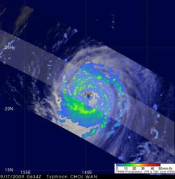
TRMM captured Super Typhoon Choi-Wan heavy rainfall on Sept. 17 at 2:34 a.m. EDT. The yellow and green areas indicate moderate rainfall between .78 to 1.57 inches per hour. Red areas near Choi-Wan\'s center are considered heavy rainfall at almost 2 inches per hour. Credit: NASA/SSAI, Hal Pierce
TRMM rainfall images are false-colored with yellow, green and red areas, which indicate rainfall between 20 and 40 millimeters (.78 to 1.57 inches) per hour.
Dark red areas are considered heavy rainfall, as much as 2 inches of rain per hour.
Rain rates in the center of the swath are from the TRMM Precipitation Radar (PR), the only spaceborne radar of its kind, while those in the outer portion are from the TRMM Microwave Imager (TMI).
The rain rates are overlaid on infrared (IR) data from the TRMM Visible Infrared Scanner (VIRS).
Media Contact
All latest news from the category: Information Technology
Here you can find a summary of innovations in the fields of information and data processing and up-to-date developments on IT equipment and hardware.
This area covers topics such as IT services, IT architectures, IT management and telecommunications.


Newest articles

A universal framework for spatial biology
SpatialData is a freely accessible tool to unify and integrate data from different omics technologies accounting for spatial information, which can provide holistic insights into health and disease. Biological processes…

How complex biological processes arise
A $20 million grant from the U.S. National Science Foundation (NSF) will support the establishment and operation of the National Synthesis Center for Emergence in the Molecular and Cellular Sciences (NCEMS) at…

Airborne single-photon lidar system achieves high-resolution 3D imaging
Compact, low-power system opens doors for photon-efficient drone and satellite-based environmental monitoring and mapping. Researchers have developed a compact and lightweight single-photon airborne lidar system that can acquire high-resolution 3D…

