ESA’s Envisat monitors oil spill
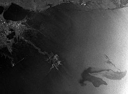
Envisat radar image of the oil spill<br>
In the black-and-white radar image the oil spill is visible as a dark grey whirl in the bottom right, while in the optical image it is seen as a white whirl. The Mississippi Delta is at top left, and the Delta National Wildlife Refuge extends out into the Gulf.
Officials report that about 1000 barrels of oil a day is escaping from a damaged oil well located 1.5 km under the drilling rig. By yesterday afternoon, the spill was covering an area some 77 km long and 63 km wide.
The US Coast Guard, the National Oceanic and Atmospheric Administration, the London-based BP and oil industry experts are attempting to stem the leak and prevent it reaching the Gulf Coast and the fragile ecosystem there.
In order to observe the clean-up efforts, the US Geological Survey, on behalf of the US Coast Guard, requested satellite maps of the area from the International Charter Space and Major Disasters. The Charter is an international collaboration, initiated by ESA and the French space agency, CNES, to put satellite remote sensing at the service of civil protection agencies and others in response to natural and man-made disasters.
Envisat acquired these images from its Advanced Synthetic Aperture Radar (black and white) and Medium Resolution Imaging Spectrometer on 26 April at 15:58 UTC and on 25 April at 16:28 UTC, respectively.
Media Contact
All latest news from the category: Ecology, The Environment and Conservation
This complex theme deals primarily with interactions between organisms and the environmental factors that impact them, but to a greater extent between individual inanimate environmental factors.
innovations-report offers informative reports and articles on topics such as climate protection, landscape conservation, ecological systems, wildlife and nature parks and ecosystem efficiency and balance.


Newest articles

A universal framework for spatial biology
SpatialData is a freely accessible tool to unify and integrate data from different omics technologies accounting for spatial information, which can provide holistic insights into health and disease. Biological processes…

How complex biological processes arise
A $20 million grant from the U.S. National Science Foundation (NSF) will support the establishment and operation of the National Synthesis Center for Emergence in the Molecular and Cellular Sciences (NCEMS) at…

Airborne single-photon lidar system achieves high-resolution 3D imaging
Compact, low-power system opens doors for photon-efficient drone and satellite-based environmental monitoring and mapping. Researchers have developed a compact and lightweight single-photon airborne lidar system that can acquire high-resolution 3D…

