Warnings dropped for ex-cyclone Paul as NASA satellites see it fizzle
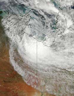
The MODIS instrument on NASA\'s Aqua satellite captured a visible image of the remnants of Cyclone Paul over the Gulf of Carpentaria, Australia at 04:45 UTC (12:45 a.m. EDT) today, April 1, 2010. Credit: NASA MODIS Rapid Response Team<br>
The Moderate Resolution Imaging Spectroradiometer or MODIS instrument on NASA's Aqua satellite captured a visible image of the remnants of Cyclone Paul over the Gulf of Carpentaria, Australia at 04:45 UTC (12:45 a.m. EDT) today, April 1, 2010. The image showed that most of the clouds associated with the low were on the southern side of the circulation and over land.
Another instrument on NASA's Aqua satellite also got a good look at Paul's remnants as the satellite flew overhead. The Atmospheric Infrared Sounder, or AIRS instrument captured an infrared image of Paul's cold remnant thunderstorm cloud tops. The infrared image, which shows temperatures, indicated that the strongest thunderstorms were still over land in the Northern Territory. The image also showed very warm land to Paul's west and south.
The only warnings in effect are for the coastal waters, where there is a wind warning posted from Coastal Nhulunbuy to the Queensland border. The warning means that winds from the west-southwest will be gusting to 20-30 knots (23- 34 mph/ 37-55 kph), easing below 25 knots (28 mph/46 kph) during Friday morning (local Darwin time). Seas are expected to be as high as 3 meters (9 feet), but the conditions are expected to ease on Friday.
On April 1 at 11:15 p.m. CST Darwin time (8:45 a.m. EDT) Paul's remnants were located close to the Northern Territory/Queensland border in the southern Gulf of Carpentaria coast. The low is expected to track inland overnight and continue to weaken over the southern Top End during the next few days.
Paul is now not expected to redevelop into a tropical cyclone.
Media Contact
More Information:
http://www.nasa.govAll latest news from the category: Earth Sciences
Earth Sciences (also referred to as Geosciences), which deals with basic issues surrounding our planet, plays a vital role in the area of energy and raw materials supply.
Earth Sciences comprises subjects such as geology, geography, geological informatics, paleontology, mineralogy, petrography, crystallography, geophysics, geodesy, glaciology, cartography, photogrammetry, meteorology and seismology, early-warning systems, earthquake research and polar research.


Newest articles

A universal framework for spatial biology
SpatialData is a freely accessible tool to unify and integrate data from different omics technologies accounting for spatial information, which can provide holistic insights into health and disease. Biological processes…

How complex biological processes arise
A $20 million grant from the U.S. National Science Foundation (NSF) will support the establishment and operation of the National Synthesis Center for Emergence in the Molecular and Cellular Sciences (NCEMS) at…

Airborne single-photon lidar system achieves high-resolution 3D imaging
Compact, low-power system opens doors for photon-efficient drone and satellite-based environmental monitoring and mapping. Researchers have developed a compact and lightweight single-photon airborne lidar system that can acquire high-resolution 3D…

