Update on Funny River Fire, southern Alaska
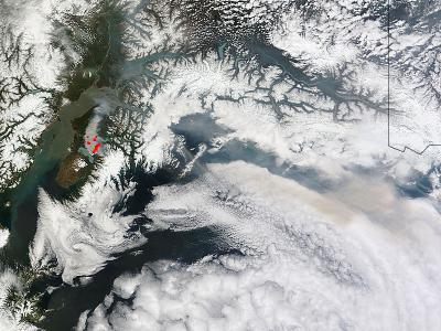
NASA's Terra satellite passed over the central Alaska and the Moderate Resolution Imaging Spectroradiometer (MODIS) instrument that flies aboard captured an image of smoke and hot spots from the Funny River Fire in southern Alaska on May 26 at 21:45 UTC (5:45 p.m. EDT). The heat from the fire appears red in the imagery and the smoke appears light brown. Credit: NASA image courtesy Jeff Schmaltz, NASA Goddard MODIS Rapid Response Team, Caption by NASA Goddard, Rob Gutro
On May 26 at 9:30 a.m. local time, the Alaska Interagency Incident Management Type 2 Team reported on the status of the fire through the multi-agency Incident Information System known as Inciweb.
At that time the fire was reported as 30 percent contained and had affected 158,585 acres. The report noted that the Funny River Fire crossed the Kenai River Sunday afternoon (May 26) near Torpedo Lake just east of the Kenai Keys.
The fire is wind driven fire and the Alaska Interagency Incident Management Type 2 Team noted that it was continuing to spread northeast toward the Skilak Lake Road.
The Lower Skilak Lake Campground was evacuated and is closed until further notice. The Kenai Keys area is under an evacuation advisory.
The Evacuation Advisory for the Kasilof area (Pollard Loop and Cardwell subdivisions) was lifted, effective Monday, May 26.
The evacuation order for the Funny River Road area between mile point 7 and the east end of the road remains in place.
The evacuation advisory for the Keys area on the north side of the Kenai River also remains in effect. For updates on the fire, visit Inciweb: http://inciweb.nwcg.gov/incident/3878/
NASA image courtesy Jeff Schmaltz, NASA Goddard MODIS Rapid Response Team, Caption by NASA Goddard, Rob Gutro
Media Contact
All latest news from the category: Earth Sciences
Earth Sciences (also referred to as Geosciences), which deals with basic issues surrounding our planet, plays a vital role in the area of energy and raw materials supply.
Earth Sciences comprises subjects such as geology, geography, geological informatics, paleontology, mineralogy, petrography, crystallography, geophysics, geodesy, glaciology, cartography, photogrammetry, meteorology and seismology, early-warning systems, earthquake research and polar research.


Newest articles

A universal framework for spatial biology
SpatialData is a freely accessible tool to unify and integrate data from different omics technologies accounting for spatial information, which can provide holistic insights into health and disease. Biological processes…

How complex biological processes arise
A $20 million grant from the U.S. National Science Foundation (NSF) will support the establishment and operation of the National Synthesis Center for Emergence in the Molecular and Cellular Sciences (NCEMS) at…

Airborne single-photon lidar system achieves high-resolution 3D imaging
Compact, low-power system opens doors for photon-efficient drone and satellite-based environmental monitoring and mapping. Researchers have developed a compact and lightweight single-photon airborne lidar system that can acquire high-resolution 3D…

