Typhoon Ma-on's Eye Seen in NASA Satellite Images
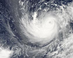
This image of Typhoon Ma-on from the MODIS instrument aboard NASA's Aqua satellite clearly shows the storm's eye, although it has some high clouds in it. The image was taken at 04:15 UTC (12:15 a.m. EDT) on July 15 as Typhoon Ma-on continues moving west in the western Pacific Ocean. Credit: NASA Goddard/MODIS Rapid Response Team, Jeff Schmaltz<br>
The Moderate Resolution Imaging Spectroradiometer (MODIS) instrument that flies aboard NASA's Aqua satellite took an image of Typhoon Ma-on that clearly shows the storm's eye, although it has some high clouds in it. The image was taken at 04:15 UTC (12:15 a.m. EDT) on July 15 as Typhoon Ma-on continues moving west in the western Pacific Ocean.
When NASA's Aqua satellite passed over Ma-on on July 14 at 03:23 UTC, the Atmospheric Infrared Sounder (AIRS) instrument captured an infrared image of the storm. The infrared image showed a large area of coldest cloud tops and the strongest thunderstorms mostly south of the center of circulation, and also revealed an eye at that time.
On July 15 at 0900 UTC (5 a.m. EDT), Typhoon Ma-on's winds were stronger than they were the day before. Maximum sustained winds are now at 115 knots (132 mph/213 kmh). Ma-on is located about 250 nautical miles south of Iwo To, Japan near 20.7 North and 140.9 East.
The strongest thunderstorms in Ma-on are still located south of the center of circulation. Visible, microwave and infrared imagery all show a well-defined eye within the storm.
Ma-on is moving to the west-northwest along the southern edge of a subtropical ridge (elongated area) of high pressure. This weekend people on Iwo To, Chici Jima and Kadena Air Base can experience rough seas and gusty winds and rains.
Ma-on is then expected to move to the north, then northeast as it curves around the western edge of the ridge. That would put Ma-on on track to skirt the eastern edge of the big island of Japan early next week.
Text credit:Rob Gutro, NASA Goddard Space Flight Center, Greenbelt, Md.
Media Contact
All latest news from the category: Earth Sciences
Earth Sciences (also referred to as Geosciences), which deals with basic issues surrounding our planet, plays a vital role in the area of energy and raw materials supply.
Earth Sciences comprises subjects such as geology, geography, geological informatics, paleontology, mineralogy, petrography, crystallography, geophysics, geodesy, glaciology, cartography, photogrammetry, meteorology and seismology, early-warning systems, earthquake research and polar research.


Newest articles

A universal framework for spatial biology
SpatialData is a freely accessible tool to unify and integrate data from different omics technologies accounting for spatial information, which can provide holistic insights into health and disease. Biological processes…

How complex biological processes arise
A $20 million grant from the U.S. National Science Foundation (NSF) will support the establishment and operation of the National Synthesis Center for Emergence in the Molecular and Cellular Sciences (NCEMS) at…

Airborne single-photon lidar system achieves high-resolution 3D imaging
Compact, low-power system opens doors for photon-efficient drone and satellite-based environmental monitoring and mapping. Researchers have developed a compact and lightweight single-photon airborne lidar system that can acquire high-resolution 3D…

