Tropical Storm Rick joins an elite late-season storm group
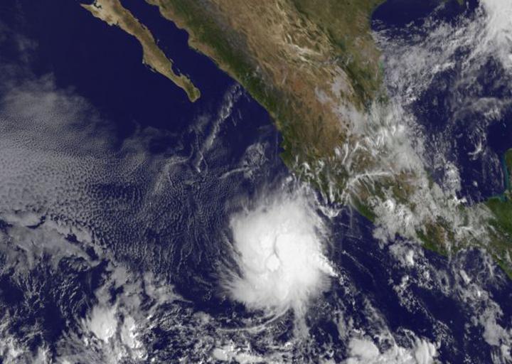
On Nov. 19 at 1500 UTC (10:00 a.m. EST) the NOAA's GOES-West satellite saw Tropical Storm Rick southwest of the western Mexican coast. Credits: NASA/NOAA GOES Project
On Nov. 19 Rick joined an elite group of tropical cyclones. The National Hurricane Center noted that only three tropical storms have formed later than this calendar date in the eastern North Pacific since reliable records began in the early 1970s.
On Nov. 19 at 1500 UTC (10:00 a.m. EST), the NOAA's GOES-West satellite saw the Tropical Storm southwest of the western Mexican coast.
National Hurricane Center forecaster Kimberlain said “First-light (GOES-West) visible imagery indicates that the low-level center is underneath a circular mass of deep convection, and there has been an increase in banding features and their associated curvature.
The increase in organization could be a sign of some decrease of the southeasterly shear that has been affecting the cyclone.”
At the time of the GOES-West image, the center of Tropical Storm Rick was located near latitude 14.7 North, longitude 105.8 West. That puts the center about 315 miles (505 km) south-southwest of Manzanillo Mexico. There are no coastal watches or warnings in effect.
Rick was moving toward the north near 7 mph (11 kph) and the National Hurricane Center expects Rick to turn toward the northwest then west-northwest by Friday, Nov. 20.
The estimated minimum central pressure is 1002 millibars.Maximum sustained winds have increased to near 40 mph (65 kph) with higher gusts. Some strengthening is forecast during the next day or two.
For updated forecasts, visit: http://www.
Media Contact
All latest news from the category: Earth Sciences
Earth Sciences (also referred to as Geosciences), which deals with basic issues surrounding our planet, plays a vital role in the area of energy and raw materials supply.
Earth Sciences comprises subjects such as geology, geography, geological informatics, paleontology, mineralogy, petrography, crystallography, geophysics, geodesy, glaciology, cartography, photogrammetry, meteorology and seismology, early-warning systems, earthquake research and polar research.


Newest articles

A universal framework for spatial biology
SpatialData is a freely accessible tool to unify and integrate data from different omics technologies accounting for spatial information, which can provide holistic insights into health and disease. Biological processes…

How complex biological processes arise
A $20 million grant from the U.S. National Science Foundation (NSF) will support the establishment and operation of the National Synthesis Center for Emergence in the Molecular and Cellular Sciences (NCEMS) at…

Airborne single-photon lidar system achieves high-resolution 3D imaging
Compact, low-power system opens doors for photon-efficient drone and satellite-based environmental monitoring and mapping. Researchers have developed a compact and lightweight single-photon airborne lidar system that can acquire high-resolution 3D…

