Tropical Storm Kirk Looks More Like a Comet on NASA Infrared Imagery
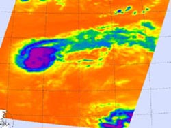
On Aug. 29 at 12:29 a.m. EDT the AIRS instrument on Aqua captured infrared data on Tropical Storm Kirk's clouds. Cloud top temperatures were colder (purple) than –63F (-52C) around the center of circulation and west of the center. That's where the strongest storms and heaviest rainfall were occurring. Kirk appears to resemble a comet because windshear is pushing clouds and showers to the northeast. Credit: NASA JPL, Ed Olsen <br>
NASA infrared imagery also revealed powerful thunderstorms around the center of circulation which are indicators that Kirk will continue strengthening. Meanwhile, another low pressure area appears to be organizing in the eastern Atlantic, far to the southeast of Kirk.
Tropical Depression Kirk formed from the eleventh tropical depression of the Atlantic Ocean season. Tropical Depression 11 formed on Aug. 28 at 5 p.m. EDT about 1,270 miles (2,045 km) east-northeast of the Lesser Antilles.
On Aug. 29 at 12:29 a.m. EDT the Atmospheric Infrared Sounder (AIRS) instrument on NASA's Aqua satellite captured infrared data on Tropical Storm Kirk's clouds. Cloud top temperatures were colder than –63F (-52C) around the center of circulation and west of the center. That's where the strongest storms and heaviest rainfall were occurring. Early on Aug. 29, wind shear was affecting Kirk from the southwest. Those winds were pushing clouds and showers associated with Kirk to the northeast giving Kirk the appearance of a “comet tail” in infrared imagery.
At 11 a.m. EDT (1500 UTC) on Aug. 29, Kirk's maximum sustained winds were near 45 mph (75 kmh) and gradual strengthening is expected. The center of Tropical Storm Kirk was about 1,135 miles (1,825) km east-northeast of the Northern Leeward Islands, near latitude 24.7 north and longitude 46.9 west. Kirk is moving toward the west-northwest near 12 mph (19 kmh), and is expected to turn northwest on Aug. 30.
Kirk is dealing with a combination of wind shear and dry air, which will make intensification a slow process. The National Hurricane Center (NHC) expects Kirk to curve to the northeast into an area of weaker wind shear, where it is expected to intensify into a hurricane over the weekend of Sept. 1-2, remaining over open ocean. Kirk is also expected to become extra-tropical on its northeastern journey.
While Kirk continues getting organized, another low pressure area is following suit in the eastern Atlantic. There's a low pressure area riding along a tropical wave, located about 700 miles west-southwest of the Cape Verde Islands, that is showing an increase in shower and thunderstorm activity. The system has a 50% chance of becoming tropical depression 12 as it moves to the westward to west-northwestward at about 15 mph (24.4 kmh) over the next couple of days.
Text Credit: Rob Gutro
NASA Goddard Space Flight Center, Greenbelt, Md.
Media Contact
All latest news from the category: Earth Sciences
Earth Sciences (also referred to as Geosciences), which deals with basic issues surrounding our planet, plays a vital role in the area of energy and raw materials supply.
Earth Sciences comprises subjects such as geology, geography, geological informatics, paleontology, mineralogy, petrography, crystallography, geophysics, geodesy, glaciology, cartography, photogrammetry, meteorology and seismology, early-warning systems, earthquake research and polar research.


Newest articles

A universal framework for spatial biology
SpatialData is a freely accessible tool to unify and integrate data from different omics technologies accounting for spatial information, which can provide holistic insights into health and disease. Biological processes…

How complex biological processes arise
A $20 million grant from the U.S. National Science Foundation (NSF) will support the establishment and operation of the National Synthesis Center for Emergence in the Molecular and Cellular Sciences (NCEMS) at…

Airborne single-photon lidar system achieves high-resolution 3D imaging
Compact, low-power system opens doors for photon-efficient drone and satellite-based environmental monitoring and mapping. Researchers have developed a compact and lightweight single-photon airborne lidar system that can acquire high-resolution 3D…

