Tropical Storm Douglas Weakening in the Eastern Pacific
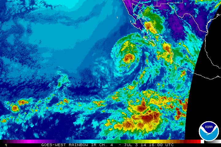
NOAA's GOES-West satellite's infrared data from July 3 at 9:15 a.m. EDT showed Douglas appeared less organized and less-round than the day before. Image Credit: NASA/NOAA GOES Project
NOAA's Geostationary Operational Environmental Satellite or GOES-West satellite captured visible data on Douglas just after sunrise on July 3 at 13:15 UTC (9:15 a.m. EDT).
The data from GOES-West was made into an image at NASA/NOAA's GOES Project at the NASA Goddard Space Flight Center in Greenbelt, Md.
Forecaster Stewart at the National Hurricane Center cited that Douglas' thunderstorm activity had been gradually waning during the early morning hours on July 3 and infrared data, such as that from the Atmospheric Infrared Sounder instrument aboard NASA's Aqua satellite showed that cloud tops were warming, which indicates cloud heights were falling and the uplift of air in the storm was weakening.
Despite that, microwave satellite data from NOAA's AMSU instrument and NASA's Tropical Rainfall Measuring Mission satellite indicated that Douglas had maintained a tight low-level circulation including a shallow eye-like feature.
On July 3 at 5 a.m. EDT (9:00 UTC), Douglas' maximum sustained winds were near 40 mph (65 kph) and the storm was weakening.
The center of Douglas was located near latitude 20.4 north and longitude 116.5 west, about 455 miles (735 km) west-southwest of the southern tip of Baja California, Mexico. Douglas is moving toward the northwest near 3 mph (6 kph).
The NHC expects Douglas to become a tropical depression late on July 3 and degenerate into a remnant low pressure area by the fourth of July.
Text credit: Rob Gutro
NASA's Goddard Space Flight Center
Media Contact
More Information:
http://www.nasa.gov/content/goddard/douglas-pacific-ocean/All latest news from the category: Earth Sciences
Earth Sciences (also referred to as Geosciences), which deals with basic issues surrounding our planet, plays a vital role in the area of energy and raw materials supply.
Earth Sciences comprises subjects such as geology, geography, geological informatics, paleontology, mineralogy, petrography, crystallography, geophysics, geodesy, glaciology, cartography, photogrammetry, meteorology and seismology, early-warning systems, earthquake research and polar research.


Newest articles

A universal framework for spatial biology
SpatialData is a freely accessible tool to unify and integrate data from different omics technologies accounting for spatial information, which can provide holistic insights into health and disease. Biological processes…

How complex biological processes arise
A $20 million grant from the U.S. National Science Foundation (NSF) will support the establishment and operation of the National Synthesis Center for Emergence in the Molecular and Cellular Sciences (NCEMS) at…

Airborne single-photon lidar system achieves high-resolution 3D imaging
Compact, low-power system opens doors for photon-efficient drone and satellite-based environmental monitoring and mapping. Researchers have developed a compact and lightweight single-photon airborne lidar system that can acquire high-resolution 3D…

