Tropical Depression 2-E forms in the Eastern Pacific, number 3 may follow
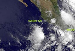
The GOES-11 satellite captured this visible image of Tropical Depression 2-E (lower right corner) and System 92E as the rounded area of clouds farther away from land (left, center) on June 16 at 12:00 UTC (8:00 a.m. EDT). Credit: NASA GOES Project<br>
The GOES-11 satellite captured a visible image of Tropical Depression 2-E and System 92E on June 16 at 12:00 UTC (8:00 a.m. EDT). GOES-11 was launched by NASA and is now operated by the National Oceanic and Atmospheric Administration (NOAA). NASA's GOES Project at the Goddard Space Flight Center in Greenbelt, Md. created the latest satellite image.
Tropical Depression 2-E (TD 2-E) formed at 8:30 a.m. PDT (11:30 a.m. EDT) today, June 16. It is located near 14.8 North and 95.6 West, or about 100 miles (160 km) south-southwest of Salina Cruz, Mexico and 225 miles (360 km) east-southeast of Punto Maldonado, Mexico. Maximum sustained winds are near 30 mph and the TD 2-E appears stationary but is expected to move in a slow west-northwestward motion later today. TD 2-E will track very close to the coast of Mexico in the next day or two. TD 2-E's minimum central pressure is 1007 millibars.
The National Hurricane Center noted that “the depression could become a tropical storm by Thursday.”
On June 14, TD 2-E started out as a low pressure areas near the Gulf of Tehuantepec. At that time, the other area of low pressure, known now as System 92E, was about 350 miles west-southwest of Acapulco, Mexico. Today, System 92E is west of TD 2-E and it is near 14.6 North and 105.7 West, approximately 275 nautical mies south-southwest of Manzanillo, Mexico. System 92 E's center is expected to continue consolidating over the next 24-36 hours, and it may become a tropical depression in that time frame.
Meanwhile, Tropical Depression 2-E poses a threat to land areas. As a result of its close proximity to land the government of Mexico has issued a tropical storm warning for the Southern coast of Mexico from Salina Cruz westward to Lagunas de Chacahua. That means tropical storm conditions are expected somewhere within the warning area within 36 hours.
In the warning areas, TD 2-E is expected to produce total rain accumulations of 4 to 8 inches along the immediate coast of Oaxaca with possible isolated maximum amounts of 12 inches. These could produce life-threatening flash floods and mudslides.
Mexico has also issued a tropical storm watch from west of Lagunas de Chacahua westward to Punta Maldonado. A tropical storm watch means that tropical storm conditions are possible within the watch area…generally within 48 hours.
If TD 2-E strengthens into a tropical storm, it would be named “Tropical Storm Blas.”
Media Contact
More Information:
http://www.nasa.govAll latest news from the category: Earth Sciences
Earth Sciences (also referred to as Geosciences), which deals with basic issues surrounding our planet, plays a vital role in the area of energy and raw materials supply.
Earth Sciences comprises subjects such as geology, geography, geological informatics, paleontology, mineralogy, petrography, crystallography, geophysics, geodesy, glaciology, cartography, photogrammetry, meteorology and seismology, early-warning systems, earthquake research and polar research.


Newest articles

A universal framework for spatial biology
SpatialData is a freely accessible tool to unify and integrate data from different omics technologies accounting for spatial information, which can provide holistic insights into health and disease. Biological processes…

How complex biological processes arise
A $20 million grant from the U.S. National Science Foundation (NSF) will support the establishment and operation of the National Synthesis Center for Emergence in the Molecular and Cellular Sciences (NCEMS) at…

Airborne single-photon lidar system achieves high-resolution 3D imaging
Compact, low-power system opens doors for photon-efficient drone and satellite-based environmental monitoring and mapping. Researchers have developed a compact and lightweight single-photon airborne lidar system that can acquire high-resolution 3D…

